You are here: Home > Network List > UW - Pacific Northwest Regional Seismic Network Stations List
> Station MRBL Marblemount, WA, USA > Earthquake Result Viewer
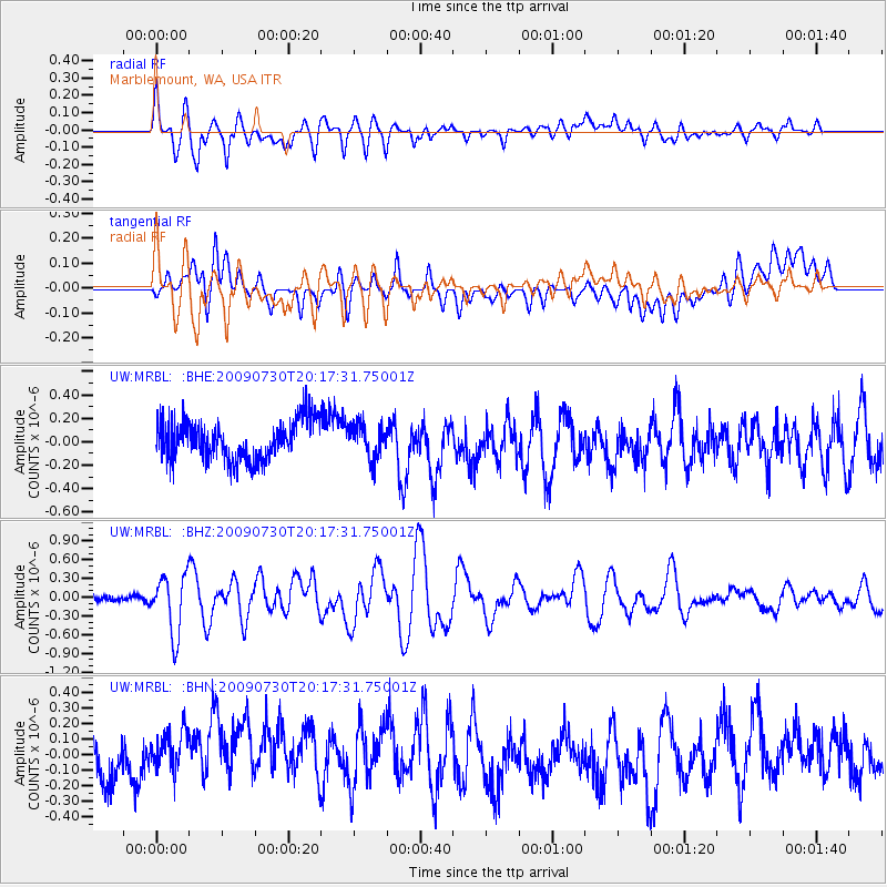
MRBL Marblemount, WA, USA - Earthquake Result Viewer
*The percent match for this event was below the threshold and hence no stack was calculated.
| Earthquake location: |
Tonga Islands |
| Earthquake latitude/longitude: |
-20.8/-174.3 |
| Earthquake time(UTC): |
2009/07/30 (211) 20:05:34 GMT |
| Earthquake Depth: |
10 km |
| Earthquake Magnitude: |
5.9 MB, 5.7 MS, 5.8 MW, 5.7 MW |
| Earthquake Catalog/Contributor: |
WHDF/NEIC |
|
| Network: |
UW Pacific Northwest Regional Seismic Network |
| Station: |
MRBL Marblemount, WA, USA |
| Lat/Lon: |
48.52 N/121.48 W |
| Elevation: |
75 m |
|
| Distance: |
83.6 deg |
| Az: |
32.19 deg |
| Baz: |
228.539 deg |
| Ray Param: |
$rayparam |
*The percent match for this event was below the threshold and hence was not used in the summary stack. |
|
| Radial Match: |
75.1556 % |
| Radial Bump: |
400 |
| Transverse Match: |
50.105076 % |
| Transverse Bump: |
400 |
| SOD ConfigId: |
2622 |
| Insert Time: |
2010-02-27 04:52:27.029 +0000 |
| GWidth: |
2.5 |
| Max Bumps: |
400 |
| Tol: |
0.001 |
|
Signal To Noise
| Channel | StoN | STA | LTA |
| UW:MRBL: :BHZ:20090730T20:17:31.75001Z | 7.680154 | 4.721063E-7 | 6.147094E-8 |
| UW:MRBL: :BHN:20090730T20:17:31.75001Z | 1.771796 | 1.9810939E-7 | 1.1181275E-7 |
| UW:MRBL: :BHE:20090730T20:17:31.75001Z | 0.868688 | 1.4658829E-7 | 1.6874677E-7 |
| Arrivals |
| Ps | |
| PpPs | |
| PsPs/PpSs | |


