You are here: Home > Network List > TA - USArray Transportable Network (new EarthScope stations) Stations List
> Station M47A Cromwell, IN, USA > Earthquake Result Viewer
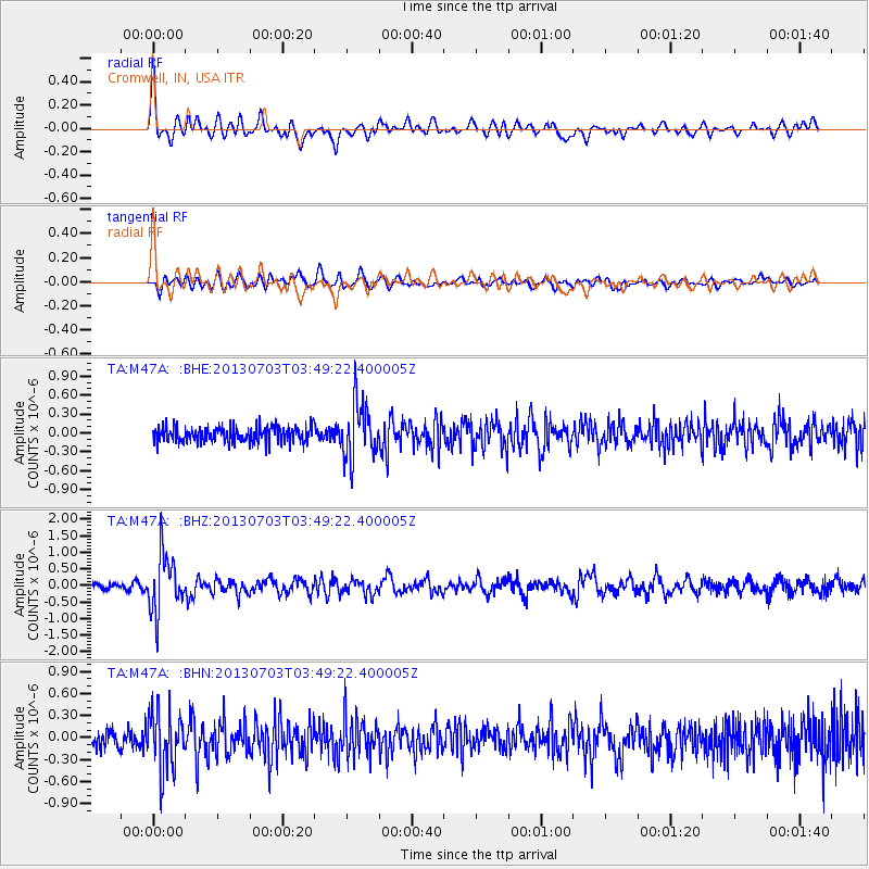
M47A Cromwell, IN, USA - Earthquake Result Viewer
*The percent match for this event was below the threshold and hence no stack was calculated.
| Earthquake location: |
Fox Islands, Aleutian Islands |
| Earthquake latitude/longitude: |
51.6/-167.0 |
| Earthquake time(UTC): |
2013/07/03 (184) 03:40:27 GMT |
| Earthquake Depth: |
5.1 km |
| Earthquake Magnitude: |
5.8 MW, 5.7 MW, 5.9 MB |
| Earthquake Catalog/Contributor: |
NEIC PDE/NEIC PDE-W |
|
| Network: |
TA USArray Transportable Network (new EarthScope stations) |
| Station: |
M47A Cromwell, IN, USA |
| Lat/Lon: |
41.36 N/85.62 W |
| Elevation: |
283 m |
|
| Distance: |
54.2 deg |
| Az: |
66.583 deg |
| Baz: |
310.536 deg |
| Ray Param: |
$rayparam |
*The percent match for this event was below the threshold and hence was not used in the summary stack. |
|
| Radial Match: |
76.29304 % |
| Radial Bump: |
400 |
| Transverse Match: |
63.16874 % |
| Transverse Bump: |
400 |
| SOD ConfigId: |
512894 |
| Insert Time: |
2013-09-15 13:40:43.174 +0000 |
| GWidth: |
2.5 |
| Max Bumps: |
400 |
| Tol: |
0.001 |
|
Signal To Noise
| Channel | StoN | STA | LTA |
| TA:M47A: :BHZ:20130703T03:49:22.400005Z | 9.21551 | 8.752695E-7 | 9.4977864E-8 |
| TA:M47A: :BHN:20130703T03:49:22.400005Z | 3.2989388 | 3.871664E-7 | 1.173609E-7 |
| TA:M47A: :BHE:20130703T03:49:22.400005Z | 3.584855 | 4.3793403E-7 | 1.2216226E-7 |
| Arrivals |
| Ps | |
| PpPs | |
| PsPs/PpSs | |


