You are here: Home > Network List > UW - Pacific Northwest Regional Seismic Network Stations List
> Station MRBL Marblemount, WA, USA > Earthquake Result Viewer
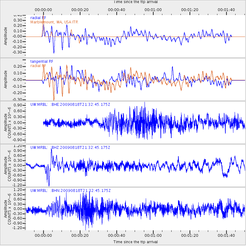
MRBL Marblemount, WA, USA - Earthquake Result Viewer
*The percent match for this event was below the threshold and hence no stack was calculated.
| Earthquake location: |
South Of Fiji Islands |
| Earthquake latitude/longitude: |
-26.1/-178.4 |
| Earthquake time(UTC): |
2009/08/18 (230) 21:20:47 GMT |
| Earthquake Depth: |
270 km |
| Earthquake Magnitude: |
5.5 MB, 6.3 MW, 6.3 MW |
| Earthquake Catalog/Contributor: |
WHDF/NEIC |
|
| Network: |
UW Pacific Northwest Regional Seismic Network |
| Station: |
MRBL Marblemount, WA, USA |
| Lat/Lon: |
48.52 N/121.48 W |
| Elevation: |
75 m |
|
| Distance: |
90.0 deg |
| Az: |
33.85 deg |
| Baz: |
228.899 deg |
| Ray Param: |
$rayparam |
*The percent match for this event was below the threshold and hence was not used in the summary stack. |
|
| Radial Match: |
63.719563 % |
| Radial Bump: |
400 |
| Transverse Match: |
54.968254 % |
| Transverse Bump: |
400 |
| SOD ConfigId: |
2622 |
| Insert Time: |
2010-02-27 04:52:30.640 +0000 |
| GWidth: |
2.5 |
| Max Bumps: |
400 |
| Tol: |
0.001 |
|
Signal To Noise
| Channel | StoN | STA | LTA |
| UW:MRBL: :BHZ:20090818T21:32:45.175Z | 4.710691 | 4.960338E-7 | 1.0529959E-7 |
| UW:MRBL: :BHN:20090818T21:32:45.175Z | 1.6598699 | 1.9133698E-7 | 1.1527227E-7 |
| UW:MRBL: :BHE:20090818T21:32:45.175Z | 1.3992878 | 1.585732E-7 | 1.1332422E-7 |
| Arrivals |
| Ps | |
| PpPs | |
| PsPs/PpSs | |


