You are here: Home > Network List > TA - USArray Transportable Network (new EarthScope stations) Stations List
> Station N40A Mertquake, Salem, IA, USA > Earthquake Result Viewer
N40A Mertquake, Salem, IA, USA - Earthquake Result Viewer
| Earthquake location: |
Fox Islands, Aleutian Islands |
| Earthquake latitude/longitude: |
51.6/-167.0 |
| Earthquake time(UTC): |
2013/07/03 (184) 03:40:27 GMT |
| Earthquake Depth: |
5.1 km |
| Earthquake Magnitude: |
5.8 MW, 5.7 MW, 5.9 MB |
| Earthquake Catalog/Contributor: |
NEIC PDE/NEIC PDE-W |
|
| Network: |
TA USArray Transportable Network (new EarthScope stations) |
| Station: |
N40A Mertquake, Salem, IA, USA |
| Lat/Lon: |
40.88 N/91.58 W |
| Elevation: |
208 m |
|
| Distance: |
51.0 deg |
| Az: |
70.67 deg |
| Baz: |
309.11 deg |
| Ray Param: |
0.067669675 |
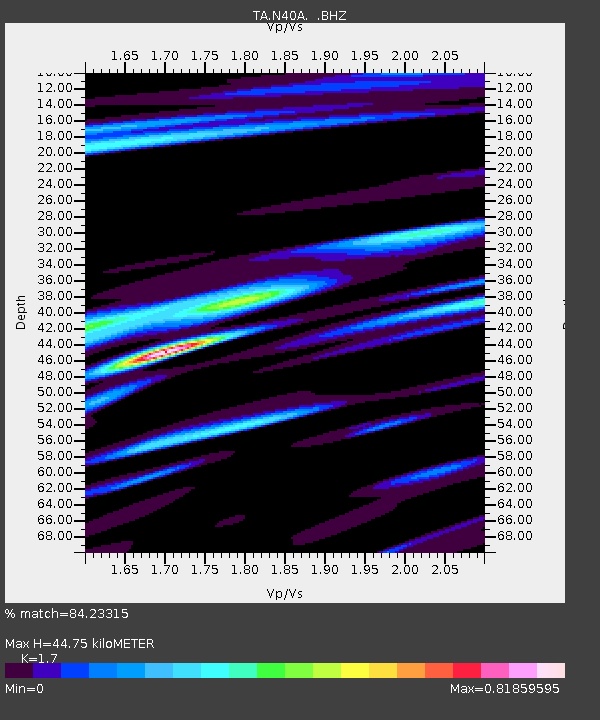
| Estimated Moho Depth: |
44.75 km |
| Estimated Crust Vp/Vs: |
1.70 |
| Assumed Crust Vp: |
6.498 km/s |
| Estimated Crust Vs: |
3.822 km/s |
| Estimated Crust Poisson's Ratio: |
0.24 |
|
| Radial Match: |
84.23315 % |
| Radial Bump: |
400 |
| Transverse Match: |
59.127476 % |
| Transverse Bump: |
400 |
| SOD ConfigId: |
512894 |
| Insert Time: |
2013-09-15 13:41:33.164 +0000 |
| GWidth: |
2.5 |
| Max Bumps: |
400 |
| Tol: |
0.001 |
|
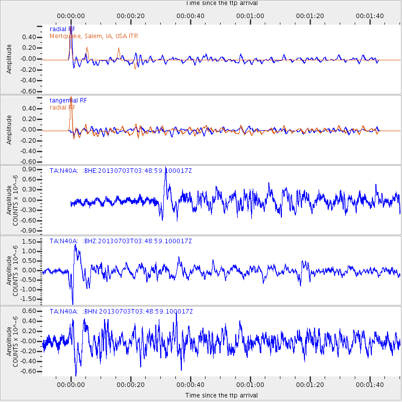
Signal To Noise
| Channel | StoN | STA | LTA |
| TA:N40A: :BHZ:20130703T03:48:59.100017Z | 11.422332 | 8.131531E-7 | 7.118977E-8 |
| TA:N40A: :BHN:20130703T03:48:59.100017Z | 3.9890022 | 3.087259E-7 | 7.739427E-8 |
| TA:N40A: :BHE:20130703T03:48:59.100017Z | 5.361912 | 3.6512233E-7 | 6.809555E-8 |
| Arrivals |
| Ps | 5.1 SECOND |
| PpPs | 17 SECOND |
| PsPs/PpSs | 23 SECOND |


