You are here: Home > Network List > TA - USArray Transportable Network (new EarthScope stations) Stations List
> Station O44A Mansfield, IL, USA > Earthquake Result Viewer
O44A Mansfield, IL, USA - Earthquake Result Viewer

| Earthquake location: |
Fox Islands, Aleutian Islands |
| Earthquake latitude/longitude: |
51.6/-167.0 |
| Earthquake time(UTC): |
2013/07/03 (184) 03:40:27 GMT |
| Earthquake Depth: |
5.1 km |
| Earthquake Magnitude: |
5.8 MW, 5.7 MW, 5.9 MB |
| Earthquake Catalog/Contributor: |
NEIC PDE/NEIC PDE-W |
|
| Network: |
TA USArray Transportable Network (new EarthScope stations) |
| Station: |
O44A Mansfield, IL, USA |
| Lat/Lon: |
40.15 N/88.47 W |
| Elevation: |
213 m |
|
| Distance: |
53.3 deg |
| Az: |
69.458 deg |
| Baz: |
310.385 deg |
| Ray Param: |
0.06617686 |
| Estimated Moho Depth: |
67.75 km |
| Estimated Crust Vp/Vs: |
2.07 |
| Assumed Crust Vp: |
6.498 km/s |
| Estimated Crust Vs: |
3.139 km/s |
| Estimated Crust Poisson's Ratio: |
0.35 |
|
| Radial Match: |
84.62243 % |
| Radial Bump: |
400 |
| Transverse Match: |
61.800915 % |
| Transverse Bump: |
400 |
| SOD ConfigId: |
512894 |
| Insert Time: |
2013-09-15 13:42:30.886 +0000 |
| GWidth: |
2.5 |
| Max Bumps: |
400 |
| Tol: |
0.001 |
|
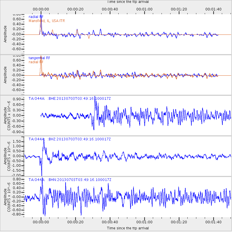
Signal To Noise
| Channel | StoN | STA | LTA |
| TA:O44A: :BHZ:20130703T03:49:16.100017Z | 10.743808 | 7.905399E-7 | 7.358098E-8 |
| TA:O44A: :BHN:20130703T03:49:16.100017Z | 5.3700714 | 4.0808007E-7 | 7.599155E-8 |
| TA:O44A: :BHE:20130703T03:49:16.100017Z | 5.9020734 | 4.4081952E-7 | 7.468892E-8 |
| Arrivals |
| Ps | 12 SECOND |
| PpPs | 31 SECOND |
| PsPs/PpSs | 42 SECOND |


