You are here: Home > Network List > CI - Caltech Regional Seismic Network Stations List
> Station SLA SLA, Trona, CA, USA > Earthquake Result Viewer
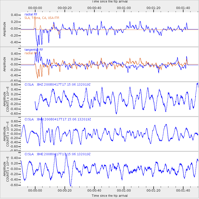
SLA SLA, Trona, CA, USA - Earthquake Result Viewer
*The percent match for this event was below the threshold and hence no stack was calculated.
| Earthquake location: |
Mariana Islands Region |
| Earthquake latitude/longitude: |
15.9/144.9 |
| Earthquake time(UTC): |
2008/04/17 (108) 17:02:52 GMT |
| Earthquake Depth: |
10 km |
| Earthquake Magnitude: |
5.5 MB, 5.2 MS, 5.5 MW, 5.5 MW |
| Earthquake Catalog/Contributor: |
WHDF/NEIC |
|
| Network: |
CI Caltech Regional Seismic Network |
| Station: |
SLA SLA, Trona, CA, USA |
| Lat/Lon: |
35.89 N/117.28 W |
| Elevation: |
1174 m |
|
| Distance: |
87.0 deg |
| Az: |
53.659 deg |
| Baz: |
287.33 deg |
| Ray Param: |
$rayparam |
*The percent match for this event was below the threshold and hence was not used in the summary stack. |
|
| Radial Match: |
75.0937 % |
| Radial Bump: |
400 |
| Transverse Match: |
70.66026 % |
| Transverse Bump: |
400 |
| SOD ConfigId: |
2504 |
| Insert Time: |
2010-02-25 20:35:27.835 +0000 |
| GWidth: |
2.5 |
| Max Bumps: |
400 |
| Tol: |
0.001 |
|
Signal To Noise
| Channel | StoN | STA | LTA |
| CI:SLA: :BHN:20080417T17:15:06.132019Z | 1.8049117 | 3.411633E-7 | 1.8901937E-7 |
| CI:SLA: :BHE:20080417T17:15:06.132019Z | 0.49380878 | 1.3741246E-7 | 2.782706E-7 |
| CI:SLA: :BHZ:20080417T17:15:06.132019Z | 1.276372 | 2.576619E-7 | 2.0187055E-7 |
| Arrivals |
| Ps | |
| PpPs | |
| PsPs/PpSs | |


