You are here: Home > Network List > TA - USArray Transportable Network (new EarthScope stations) Stations List
> Station Q46A CEJHS Indians, Carlisle, IN, USA > Earthquake Result Viewer
Q46A CEJHS Indians, Carlisle, IN, USA - Earthquake Result Viewer
| Earthquake location: |
Fox Islands, Aleutian Islands |
| Earthquake latitude/longitude: |
51.6/-167.0 |
| Earthquake time(UTC): |
2013/07/03 (184) 03:40:27 GMT |
| Earthquake Depth: |
5.1 km |
| Earthquake Magnitude: |
5.8 MW, 5.7 MW, 5.9 MB |
| Earthquake Catalog/Contributor: |
NEIC PDE/NEIC PDE-W |
|
| Network: |
TA USArray Transportable Network (new EarthScope stations) |
| Station: |
Q46A CEJHS Indians, Carlisle, IN, USA |
| Lat/Lon: |
39.02 N/87.36 W |
| Elevation: |
164 m |
|
| Distance: |
54.7 deg |
| Az: |
69.82 deg |
| Baz: |
311.301 deg |
| Ray Param: |
0.06527787 |
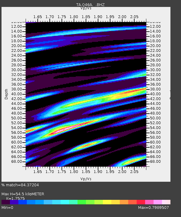
| Estimated Moho Depth: |
54.5 km |
| Estimated Crust Vp/Vs: |
1.76 |
| Assumed Crust Vp: |
6.444 km/s |
| Estimated Crust Vs: |
3.667 km/s |
| Estimated Crust Poisson's Ratio: |
0.26 |
|
| Radial Match: |
84.37204 % |
| Radial Bump: |
400 |
| Transverse Match: |
58.88673 % |
| Transverse Bump: |
400 |
| SOD ConfigId: |
512894 |
| Insert Time: |
2013-09-15 13:44:17.557 +0000 |
| GWidth: |
2.5 |
| Max Bumps: |
400 |
| Tol: |
0.001 |
|
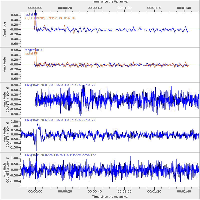
Signal To Noise
| Channel | StoN | STA | LTA |
| TA:Q46A: :BHZ:20130703T03:49:26.225017Z | 5.08327 | 8.5586896E-7 | 1.6836975E-7 |
| TA:Q46A: :BHN:20130703T03:49:26.225017Z | 1.3264087 | 4.544236E-7 | 3.4259693E-7 |
| TA:Q46A: :BHE:20130703T03:49:26.225017Z | 1.832893 | 4.4912795E-7 | 2.4503774E-7 |
| Arrivals |
| Ps | 6.8 SECOND |
| PpPs | 22 SECOND |
| PsPs/PpSs | 29 SECOND |


