You are here: Home > Network List > TA - USArray Transportable Network (new EarthScope stations) Stations List
> Station R55A Marlinton, WV, USA > Earthquake Result Viewer
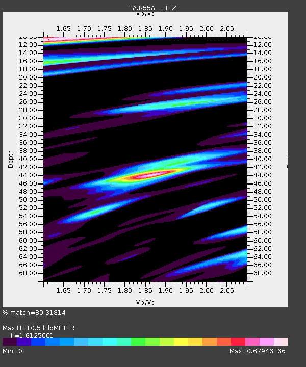
R55A Marlinton, WV, USA - Earthquake Result Viewer
| Earthquake location: |
Fox Islands, Aleutian Islands |
| Earthquake latitude/longitude: |
51.6/-167.0 |
| Earthquake time(UTC): |
2013/07/03 (184) 03:40:27 GMT |
| Earthquake Depth: |
5.1 km |
| Earthquake Magnitude: |
5.8 MW, 5.7 MW, 5.9 MB |
| Earthquake Catalog/Contributor: |
NEIC PDE/NEIC PDE-W |
|
| Network: |
TA USArray Transportable Network (new EarthScope stations) |
| Station: |
R55A Marlinton, WV, USA |
| Lat/Lon: |
38.28 N/80.12 W |
| Elevation: |
833 m |
|
| Distance: |
59.4 deg |
| Az: |
65.91 deg |
| Baz: |
313.679 deg |
| Ray Param: |
0.062220346 |
| Estimated Moho Depth: |
10.5 km |
| Estimated Crust Vp/Vs: |
1.61 |
| Assumed Crust Vp: |
6.207 km/s |
| Estimated Crust Vs: |
3.849 km/s |
| Estimated Crust Poisson's Ratio: |
0.19 |
|
| Radial Match: |
80.31814 % |
| Radial Bump: |
400 |
| Transverse Match: |
56.001804 % |
| Transverse Bump: |
400 |
| SOD ConfigId: |
512894 |
| Insert Time: |
2013-09-15 13:45:32.492 +0000 |
| GWidth: |
2.5 |
| Max Bumps: |
400 |
| Tol: |
0.001 |
|

Signal To Noise
| Channel | StoN | STA | LTA |
| TA:R55A: :BHZ:20130703T03:49:59.275005Z | 4.6153264 | 7.848735E-7 | 1.7005807E-7 |
| TA:R55A: :BHN:20130703T03:49:59.275005Z | 2.9446208 | 2.7498274E-7 | 9.338476E-8 |
| TA:R55A: :BHE:20130703T03:49:59.275005Z | 3.2545075 | 3.7815008E-7 | 1.1619272E-7 |
| Arrivals |
| Ps | 1.1 SECOND |
| PpPs | 4.2 SECOND |
| PsPs/PpSs | 5.3 SECOND |


