You are here: Home > Network List > TA - USArray Transportable Network (new EarthScope stations) Stations List
> Station T47A Sharon Grove, KY, USA > Earthquake Result Viewer
T47A Sharon Grove, KY, USA - Earthquake Result Viewer
| Earthquake location: |
Fox Islands, Aleutian Islands |
| Earthquake latitude/longitude: |
51.6/-167.0 |
| Earthquake time(UTC): |
2013/07/03 (184) 03:40:27 GMT |
| Earthquake Depth: |
5.1 km |
| Earthquake Magnitude: |
5.8 MW, 5.7 MW, 5.9 MB |
| Earthquake Catalog/Contributor: |
NEIC PDE/NEIC PDE-W |
|
| Network: |
TA USArray Transportable Network (new EarthScope stations) |
| Station: |
T47A Sharon Grove, KY, USA |
| Lat/Lon: |
36.99 N/87.11 W |
| Elevation: |
217 m |
|
| Distance: |
56.2 deg |
| Az: |
71.495 deg |
| Baz: |
312.405 deg |
| Ray Param: |
0.06428763 |
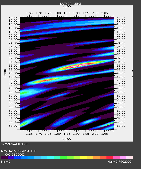
| Estimated Moho Depth: |
35.75 km |
| Estimated Crust Vp/Vs: |
1.91 |
| Assumed Crust Vp: |
6.444 km/s |
| Estimated Crust Vs: |
3.374 km/s |
| Estimated Crust Poisson's Ratio: |
0.31 |
|
| Radial Match: |
88.96961 % |
| Radial Bump: |
400 |
| Transverse Match: |
68.85165 % |
| Transverse Bump: |
400 |
| SOD ConfigId: |
512894 |
| Insert Time: |
2013-09-15 13:47:07.355 +0000 |
| GWidth: |
2.5 |
| Max Bumps: |
400 |
| Tol: |
0.001 |
|
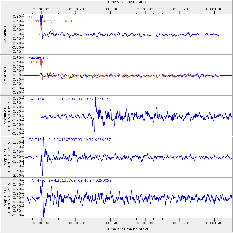
Signal To Noise
| Channel | StoN | STA | LTA |
| TA:T47A: :BHZ:20130703T03:49:37.025005Z | 12.539416 | 8.1349316E-7 | 6.487488E-8 |
| TA:T47A: :BHN:20130703T03:49:37.025005Z | 5.678318 | 3.792524E-7 | 6.678957E-8 |
| TA:T47A: :BHE:20130703T03:49:37.025005Z | 8.258292 | 3.6671483E-7 | 4.4405645E-8 |
| Arrivals |
| Ps | 5.3 SECOND |
| PpPs | 15 SECOND |
| PsPs/PpSs | 21 SECOND |


