You are here: Home > Network List > TA - USArray Transportable Network (new EarthScope stations) Stations List
> Station U48A Cassie Pea, Portland, TN, USA > Earthquake Result Viewer
U48A Cassie Pea, Portland, TN, USA - Earthquake Result Viewer
| Earthquake location: |
Fox Islands, Aleutian Islands |
| Earthquake latitude/longitude: |
51.6/-167.0 |
| Earthquake time(UTC): |
2013/07/03 (184) 03:40:27 GMT |
| Earthquake Depth: |
5.1 km |
| Earthquake Magnitude: |
5.8 MW, 5.7 MW, 5.9 MB |
| Earthquake Catalog/Contributor: |
NEIC PDE/NEIC PDE-W |
|
| Network: |
TA USArray Transportable Network (new EarthScope stations) |
| Station: |
U48A Cassie Pea, Portland, TN, USA |
| Lat/Lon: |
36.51 N/86.54 W |
| Elevation: |
268 m |
|
| Distance: |
56.9 deg |
| Az: |
71.548 deg |
| Baz: |
312.771 deg |
| Ray Param: |
0.06385803 |
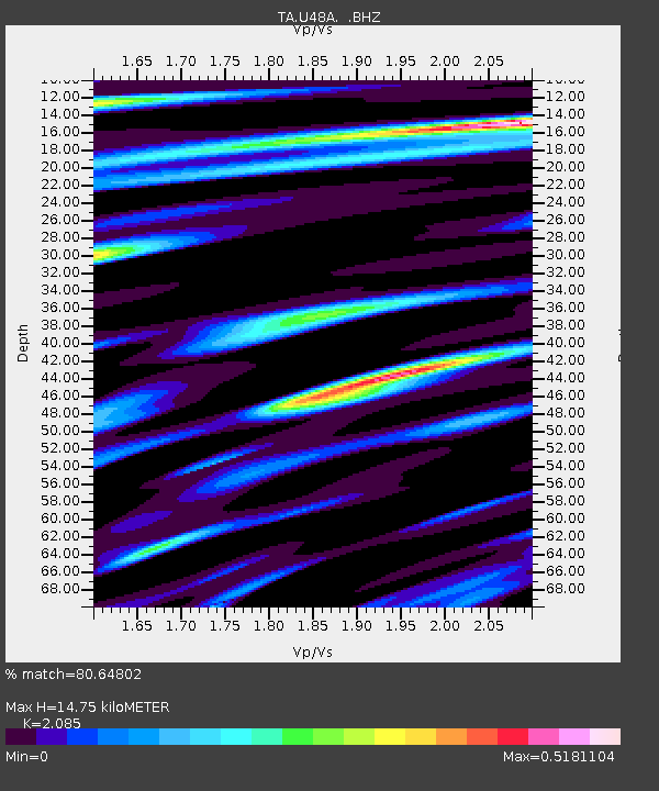
| Estimated Moho Depth: |
14.75 km |
| Estimated Crust Vp/Vs: |
2.09 |
| Assumed Crust Vp: |
6.444 km/s |
| Estimated Crust Vs: |
3.091 km/s |
| Estimated Crust Poisson's Ratio: |
0.35 |
|
| Radial Match: |
80.64802 % |
| Radial Bump: |
400 |
| Transverse Match: |
69.99797 % |
| Transverse Bump: |
400 |
| SOD ConfigId: |
512894 |
| Insert Time: |
2013-09-15 13:48:10.102 +0000 |
| GWidth: |
2.5 |
| Max Bumps: |
400 |
| Tol: |
0.001 |
|

Signal To Noise
| Channel | StoN | STA | LTA |
| TA:U48A: :BHZ:20130703T03:49:41.675029Z | 7.850382 | 7.8134525E-7 | 9.9529586E-8 |
| TA:U48A: :BHN:20130703T03:49:41.675029Z | 4.1841044 | 2.5955228E-7 | 6.203294E-8 |
| TA:U48A: :BHE:20130703T03:49:41.675029Z | 4.493654 | 2.9812136E-7 | 6.634276E-8 |
| Arrivals |
| Ps | 2.6 SECOND |
| PpPs | 6.8 SECOND |
| PsPs/PpSs | 9.4 SECOND |


