You are here: Home > Network List > UW - Pacific Northwest Regional Seismic Network Stations List
> Station MRBL Marblemount, WA, USA > Earthquake Result Viewer
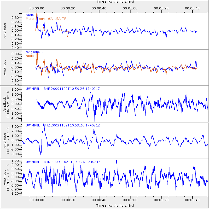
MRBL Marblemount, WA, USA - Earthquake Result Viewer
*The percent match for this event was below the threshold and hence no stack was calculated.
| Earthquake location: |
South Of Tonga Islands |
| Earthquake latitude/longitude: |
-24.1/-175.2 |
| Earthquake time(UTC): |
2009/11/02 (306) 10:47:13 GMT |
| Earthquake Depth: |
9.0 km |
| Earthquake Magnitude: |
6.1 MB, 6.1 MS, 6.2 MW, 6.1 MW |
| Earthquake Catalog/Contributor: |
WHDF/NEIC |
|
| Network: |
UW Pacific Northwest Regional Seismic Network |
| Station: |
MRBL Marblemount, WA, USA |
| Lat/Lon: |
48.52 N/121.48 W |
| Elevation: |
75 m |
|
| Distance: |
86.8 deg |
| Az: |
32.453 deg |
| Baz: |
227.513 deg |
| Ray Param: |
$rayparam |
*The percent match for this event was below the threshold and hence was not used in the summary stack. |
|
| Radial Match: |
71.69413 % |
| Radial Bump: |
400 |
| Transverse Match: |
65.7912 % |
| Transverse Bump: |
400 |
| SOD ConfigId: |
2622 |
| Insert Time: |
2010-02-27 04:52:54.988 +0000 |
| GWidth: |
2.5 |
| Max Bumps: |
400 |
| Tol: |
0.001 |
|
Signal To Noise
| Channel | StoN | STA | LTA |
| UW:MRBL: :BHZ:20091102T10:59:26.174021Z | 5.901369 | 1.9291836E-6 | 3.2690443E-7 |
| UW:MRBL: :BHN:20091102T10:59:26.174021Z | 1.9384825 | 4.734384E-7 | 2.4423144E-7 |
| UW:MRBL: :BHE:20091102T10:59:26.174021Z | 2.8623705 | 7.153541E-7 | 2.4991667E-7 |
| Arrivals |
| Ps | |
| PpPs | |
| PsPs/PpSs | |


