You are here: Home > Network List > UW - Pacific Northwest Regional Seismic Network Stations List
> Station MRBL Marblemount, WA, USA > Earthquake Result Viewer
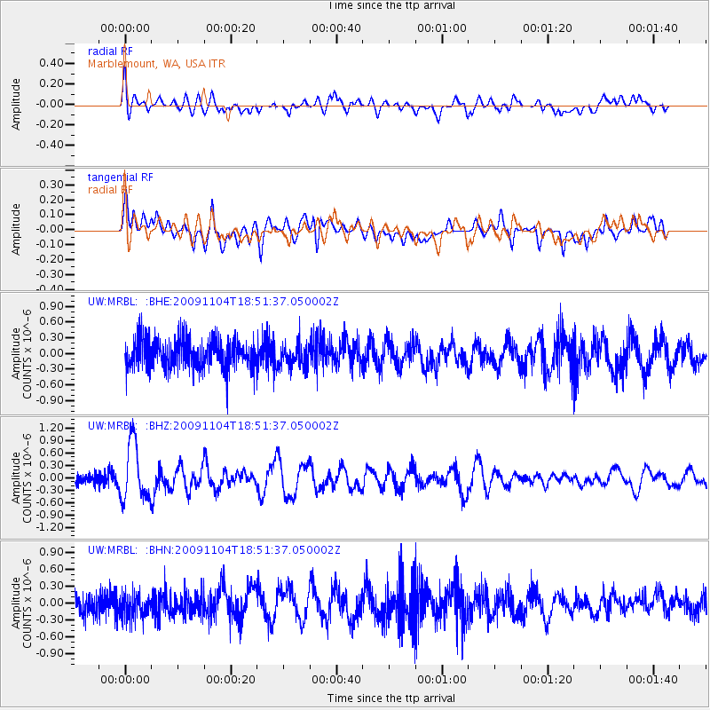
MRBL Marblemount, WA, USA - Earthquake Result Viewer
*The percent match for this event was below the threshold and hence no stack was calculated.
| Earthquake location: |
Azores Islands Region |
| Earthquake latitude/longitude: |
36.2/-33.9 |
| Earthquake time(UTC): |
2009/11/04 (308) 18:41:44 GMT |
| Earthquake Depth: |
10 km |
| Earthquake Magnitude: |
5.7 MB, 5.6 MS, 5.9 MW, 5.8 MW |
| Earthquake Catalog/Contributor: |
WHDF/NEIC |
|
| Network: |
UW Pacific Northwest Regional Seismic Network |
| Station: |
MRBL Marblemount, WA, USA |
| Lat/Lon: |
48.52 N/121.48 W |
| Elevation: |
75 m |
|
| Distance: |
62.5 deg |
| Az: |
311.525 deg |
| Baz: |
65.687 deg |
| Ray Param: |
$rayparam |
*The percent match for this event was below the threshold and hence was not used in the summary stack. |
|
| Radial Match: |
41.330315 % |
| Radial Bump: |
400 |
| Transverse Match: |
56.308987 % |
| Transverse Bump: |
400 |
| SOD ConfigId: |
2622 |
| Insert Time: |
2010-02-27 04:52:55.946 +0000 |
| GWidth: |
2.5 |
| Max Bumps: |
400 |
| Tol: |
0.001 |
|
Signal To Noise
| Channel | StoN | STA | LTA |
| UW:MRBL: :BHZ:20091104T18:51:37.050002Z | 4.654812 | 6.967587E-7 | 1.496857E-7 |
| UW:MRBL: :BHN:20091104T18:51:37.050002Z | 0.8600789 | 2.0674534E-7 | 2.403795E-7 |
| UW:MRBL: :BHE:20091104T18:51:37.050002Z | 0.8075636 | 2.2261817E-7 | 2.7566642E-7 |
| Arrivals |
| Ps | |
| PpPs | |
| PsPs/PpSs | |


