You are here: Home > Network List > TA - USArray Transportable Network (new EarthScope stations) Stations List
> Station W39A Magazine, AR, USA > Earthquake Result Viewer
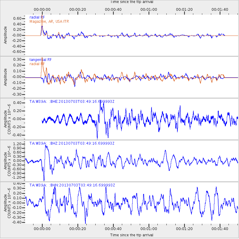
W39A Magazine, AR, USA - Earthquake Result Viewer

| Earthquake location: |
Fox Islands, Aleutian Islands |
| Earthquake latitude/longitude: |
51.6/-167.0 |
| Earthquake time(UTC): |
2013/07/03 (184) 03:40:27 GMT |
| Earthquake Depth: |
5.1 km |
| Earthquake Magnitude: |
5.8 MW, 5.7 MW, 5.9 MB |
| Earthquake Catalog/Contributor: |
NEIC PDE/NEIC PDE-W |
|
| Network: |
TA USArray Transportable Network (new EarthScope stations) |
| Station: |
W39A Magazine, AR, USA |
| Lat/Lon: |
35.20 N/93.78 W |
| Elevation: |
162 m |
|
| Distance: |
53.4 deg |
| Az: |
77.558 deg |
| Baz: |
311.981 deg |
| Ray Param: |
0.06612333 |
| Estimated Moho Depth: |
13.5 km |
| Estimated Crust Vp/Vs: |
2.08 |
| Assumed Crust Vp: |
6.498 km/s |
| Estimated Crust Vs: |
3.124 km/s |
| Estimated Crust Poisson's Ratio: |
0.35 |
|
| Radial Match: |
83.205376 % |
| Radial Bump: |
400 |
| Transverse Match: |
77.67661 % |
| Transverse Bump: |
400 |
| SOD ConfigId: |
512894 |
| Insert Time: |
2013-09-15 13:49:41.942 +0000 |
| GWidth: |
2.5 |
| Max Bumps: |
400 |
| Tol: |
0.001 |
|
Signal To Noise
| Channel | StoN | STA | LTA |
| TA:W39A: :BHZ:20130703T03:49:16.699993Z | 6.873828 | 7.5770635E-7 | 1.1023063E-7 |
| TA:W39A: :BHN:20130703T03:49:16.699993Z | 3.0107825 | 1.9448787E-7 | 6.459712E-8 |
| TA:W39A: :BHE:20130703T03:49:16.699993Z | 3.7427094 | 2.536778E-7 | 6.777919E-8 |
| Arrivals |
| Ps | 2.4 SECOND |
| PpPs | 6.1 SECOND |
| PsPs/PpSs | 8.5 SECOND |


