You are here: Home > Network List > UW - Pacific Northwest Regional Seismic Network Stations List
> Station MRBL Marblemount, WA, USA > Earthquake Result Viewer
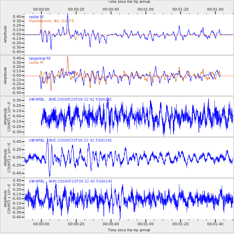
MRBL Marblemount, WA, USA - Earthquake Result Viewer
*The percent match for this event was below the threshold and hence no stack was calculated.
| Earthquake location: |
Vanuatu Islands |
| Earthquake latitude/longitude: |
-17.0/168.3 |
| Earthquake time(UTC): |
2009/05/29 (149) 06:20:14 GMT |
| Earthquake Depth: |
13 km |
| Earthquake Magnitude: |
5.5 MB, 5.5 MS, 5.7 MW, 5.6 MW |
| Earthquake Catalog/Contributor: |
WHDF/NEIC |
|
| Network: |
UW Pacific Northwest Regional Seismic Network |
| Station: |
MRBL Marblemount, WA, USA |
| Lat/Lon: |
48.52 N/121.48 W |
| Elevation: |
75 m |
|
| Distance: |
90.1 deg |
| Az: |
38.72 deg |
| Baz: |
244.169 deg |
| Ray Param: |
$rayparam |
*The percent match for this event was below the threshold and hence was not used in the summary stack. |
|
| Radial Match: |
63.481396 % |
| Radial Bump: |
400 |
| Transverse Match: |
67.71095 % |
| Transverse Bump: |
400 |
| SOD ConfigId: |
2648 |
| Insert Time: |
2010-02-27 04:52:56.986 +0000 |
| GWidth: |
2.5 |
| Max Bumps: |
400 |
| Tol: |
0.001 |
|
Signal To Noise
| Channel | StoN | STA | LTA |
| UW:MRBL: :BHZ:20090529T06:32:42.599014Z | 3.1028838 | 2.1518196E-7 | 6.934902E-8 |
| UW:MRBL: :BHN:20090529T06:32:42.599014Z | 1.3791485 | 1.3046362E-7 | 9.459723E-8 |
| UW:MRBL: :BHE:20090529T06:32:42.599014Z | 1.1193961 | 1.15591746E-7 | 1.0326259E-7 |
| Arrivals |
| Ps | |
| PpPs | |
| PsPs/PpSs | |


