You are here: Home > Network List > TA - USArray Transportable Network (new EarthScope stations) Stations List
> Station X50B Fort Payne, AL, USA > Earthquake Result Viewer
X50B Fort Payne, AL, USA - Earthquake Result Viewer

| Earthquake location: |
Fox Islands, Aleutian Islands |
| Earthquake latitude/longitude: |
51.6/-167.0 |
| Earthquake time(UTC): |
2013/07/03 (184) 03:40:27 GMT |
| Earthquake Depth: |
5.1 km |
| Earthquake Magnitude: |
5.8 MW, 5.7 MW, 5.9 MB |
| Earthquake Catalog/Contributor: |
NEIC PDE/NEIC PDE-W |
|
| Network: |
TA USArray Transportable Network (new EarthScope stations) |
| Station: |
X50B Fort Payne, AL, USA |
| Lat/Lon: |
34.46 N/85.65 W |
| Elevation: |
494 m |
|
| Distance: |
58.8 deg |
| Az: |
72.715 deg |
| Baz: |
313.907 deg |
| Ray Param: |
0.06260607 |
| Estimated Moho Depth: |
46.0 km |
| Estimated Crust Vp/Vs: |
2.10 |
| Assumed Crust Vp: |
6.35 km/s |
| Estimated Crust Vs: |
3.027 km/s |
| Estimated Crust Poisson's Ratio: |
0.35 |
|
| Radial Match: |
83.50094 % |
| Radial Bump: |
400 |
| Transverse Match: |
56.03516 % |
| Transverse Bump: |
400 |
| SOD ConfigId: |
512894 |
| Insert Time: |
2013-09-15 13:50:57.007 +0000 |
| GWidth: |
2.5 |
| Max Bumps: |
400 |
| Tol: |
0.001 |
|
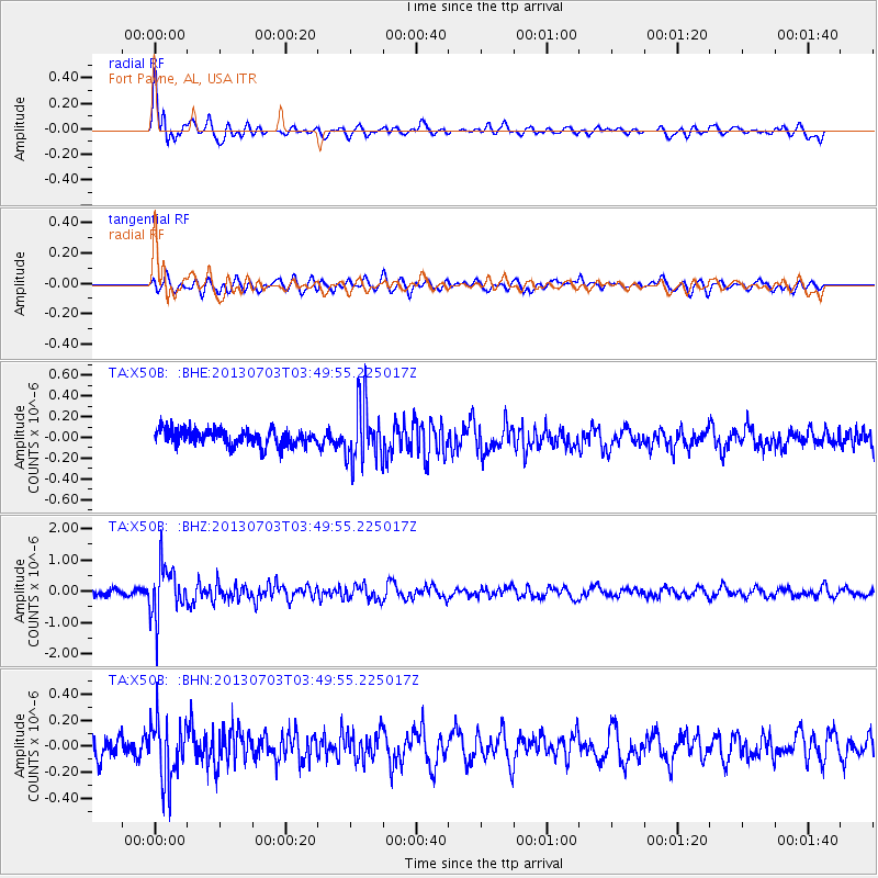
Signal To Noise
| Channel | StoN | STA | LTA |
| TA:X50B: :BHZ:20130703T03:49:55.225017Z | 6.9777465 | 8.202585E-7 | 1.1755349E-7 |
| TA:X50B: :BHN:20130703T03:49:55.225017Z | 3.040416 | 2.3740844E-7 | 7.808419E-8 |
| TA:X50B: :BHE:20130703T03:49:55.225017Z | 3.6928332 | 2.864817E-7 | 7.757775E-8 |
| Arrivals |
| Ps | 8.3 SECOND |
| PpPs | 22 SECOND |
| PsPs/PpSs | 30 SECOND |


