You are here: Home > Network List > UW - Pacific Northwest Regional Seismic Network Stations List
> Station MRBL Marblemount, WA, USA > Earthquake Result Viewer
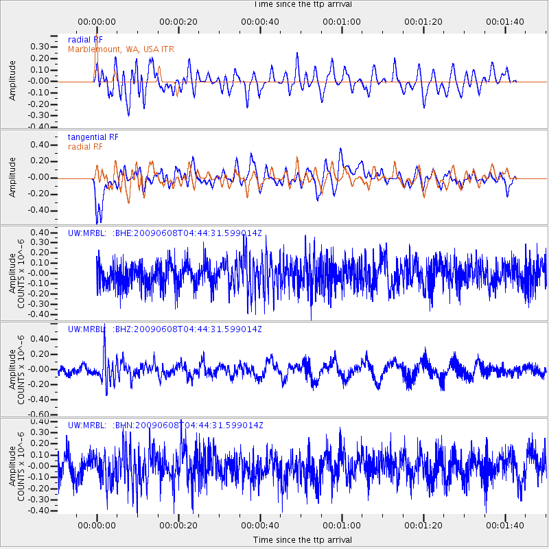
MRBL Marblemount, WA, USA - Earthquake Result Viewer
*The percent match for this event was below the threshold and hence no stack was calculated.
| Earthquake location: |
South Of Fiji Islands |
| Earthquake latitude/longitude: |
-22.2/-179.6 |
| Earthquake time(UTC): |
2009/06/08 (159) 04:33:19 GMT |
| Earthquake Depth: |
612 km |
| Earthquake Magnitude: |
5.5 MW, 5.2 MB |
| Earthquake Catalog/Contributor: |
WHDF/NEIC |
|
| Network: |
UW Pacific Northwest Regional Seismic Network |
| Station: |
MRBL Marblemount, WA, USA |
| Lat/Lon: |
48.52 N/121.48 W |
| Elevation: |
75 m |
|
| Distance: |
87.5 deg |
| Az: |
34.415 deg |
| Baz: |
231.963 deg |
| Ray Param: |
$rayparam |
*The percent match for this event was below the threshold and hence was not used in the summary stack. |
|
| Radial Match: |
53.257187 % |
| Radial Bump: |
400 |
| Transverse Match: |
57.85454 % |
| Transverse Bump: |
400 |
| SOD ConfigId: |
2648 |
| Insert Time: |
2010-02-27 04:53:04.505 +0000 |
| GWidth: |
2.5 |
| Max Bumps: |
400 |
| Tol: |
0.001 |
|
Signal To Noise
| Channel | StoN | STA | LTA |
| UW:MRBL: :BHZ:20090608T04:44:31.599014Z | 3.35368 | 1.7711379E-7 | 5.2811775E-8 |
| UW:MRBL: :BHN:20090608T04:44:31.599014Z | 1.1261207 | 1.2144088E-7 | 1.07840016E-7 |
| UW:MRBL: :BHE:20090608T04:44:31.599014Z | 1.0226309 | 1.1104872E-7 | 1.085912E-7 |
| Arrivals |
| Ps | |
| PpPs | |
| PsPs/PpSs | |


