You are here: Home > Network List > TA - USArray Transportable Network (new EarthScope stations) Stations List
> Station X58A Rowland, NC, USA > Earthquake Result Viewer
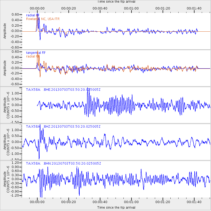
X58A Rowland, NC, USA - Earthquake Result Viewer
*The percent match for this event was below the threshold and hence no stack was calculated.
| Earthquake location: |
Fox Islands, Aleutian Islands |
| Earthquake latitude/longitude: |
51.6/-167.0 |
| Earthquake time(UTC): |
2013/07/03 (184) 03:40:27 GMT |
| Earthquake Depth: |
5.1 km |
| Earthquake Magnitude: |
5.8 MW, 5.7 MW, 5.9 MB |
| Earthquake Catalog/Contributor: |
NEIC PDE/NEIC PDE-W |
|
| Network: |
TA USArray Transportable Network (new EarthScope stations) |
| Station: |
X58A Rowland, NC, USA |
| Lat/Lon: |
34.55 N/79.34 W |
| Elevation: |
45 m |
|
| Distance: |
62.5 deg |
| Az: |
68.439 deg |
| Baz: |
315.37 deg |
| Ray Param: |
$rayparam |
*The percent match for this event was below the threshold and hence was not used in the summary stack. |
|
| Radial Match: |
74.8482 % |
| Radial Bump: |
400 |
| Transverse Match: |
59.557556 % |
| Transverse Bump: |
400 |
| SOD ConfigId: |
512894 |
| Insert Time: |
2013-09-15 13:51:19.582 +0000 |
| GWidth: |
2.5 |
| Max Bumps: |
400 |
| Tol: |
0.001 |
|
Signal To Noise
| Channel | StoN | STA | LTA |
| TA:X58A: :BHZ:20130703T03:50:20.025005Z | 2.9640682 | 6.7119345E-7 | 2.2644332E-7 |
| TA:X58A: :BHN:20130703T03:50:20.025005Z | 2.6468885 | 5.360098E-7 | 2.0250562E-7 |
| TA:X58A: :BHE:20130703T03:50:20.025005Z | 3.7837014 | 6.5431226E-7 | 1.7292915E-7 |
| Arrivals |
| Ps | |
| PpPs | |
| PsPs/PpSs | |


