You are here: Home > Network List > TA - USArray Transportable Network (new EarthScope stations) Stations List
> Station Y22D IRIS PASSCAL Instrument Center, Socorro, NM, USA > Earthquake Result Viewer
Y22D IRIS PASSCAL Instrument Center, Socorro, NM, USA - Earthquake Result Viewer

| Earthquake location: |
Fox Islands, Aleutian Islands |
| Earthquake latitude/longitude: |
51.6/-167.0 |
| Earthquake time(UTC): |
2013/07/03 (184) 03:40:27 GMT |
| Earthquake Depth: |
5.1 km |
| Earthquake Magnitude: |
5.8 MW, 5.7 MW, 5.9 MB |
| Earthquake Catalog/Contributor: |
NEIC PDE/NEIC PDE-W |
|
| Network: |
TA USArray Transportable Network (new EarthScope stations) |
| Station: |
Y22D IRIS PASSCAL Instrument Center, Socorro, NM, USA |
| Lat/Lon: |
34.08 N/106.92 W |
| Elevation: |
1436 m |
|
| Distance: |
46.0 deg |
| Az: |
88.068 deg |
| Baz: |
311.343 deg |
| Ray Param: |
0.070900954 |
| Estimated Moho Depth: |
36.0 km |
| Estimated Crust Vp/Vs: |
2.04 |
| Assumed Crust Vp: |
6.502 km/s |
| Estimated Crust Vs: |
3.187 km/s |
| Estimated Crust Poisson's Ratio: |
0.34 |
|
| Radial Match: |
80.50143 % |
| Radial Bump: |
400 |
| Transverse Match: |
77.355644 % |
| Transverse Bump: |
400 |
| SOD ConfigId: |
512894 |
| Insert Time: |
2013-09-15 13:51:31.060 +0000 |
| GWidth: |
2.5 |
| Max Bumps: |
400 |
| Tol: |
0.001 |
|
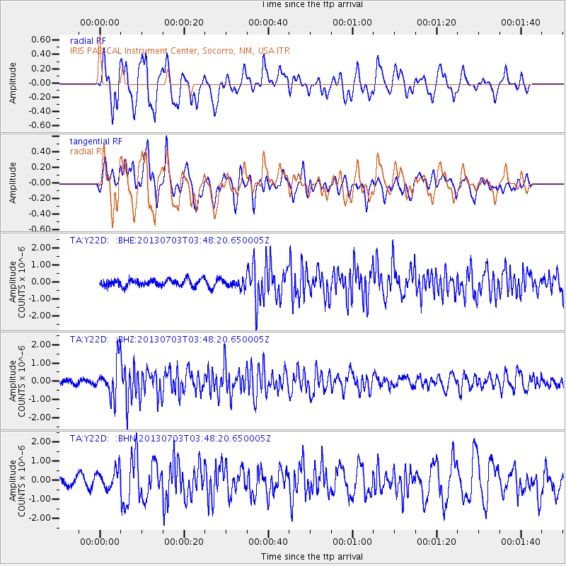
Signal To Noise
| Channel | StoN | STA | LTA |
| TA:Y22D: :BHZ:20130703T03:48:20.650005Z | 7.715764 | 9.722028E-7 | 1.2600213E-7 |
| TA:Y22D: :BHN:20130703T03:48:20.650005Z | 2.496602 | 5.2622454E-7 | 2.1077629E-7 |
| TA:Y22D: :BHE:20130703T03:48:20.650005Z | 1.1757427 | 2.3109503E-7 | 1.9655238E-7 |
| Arrivals |
| Ps | 6.1 SECOND |
| PpPs | 16 SECOND |
| PsPs/PpSs | 22 SECOND |


