You are here: Home > Network List > UW - Pacific Northwest Regional Seismic Network Stations List
> Station MRBL Marblemount, WA, USA > Earthquake Result Viewer
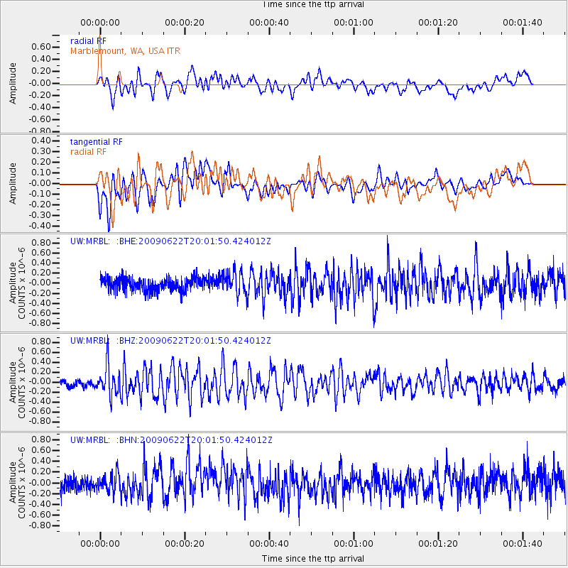
MRBL Marblemount, WA, USA - Earthquake Result Viewer
*The percent match for this event was below the threshold and hence no stack was calculated.
| Earthquake location: |
Andreanof Islands, Aleutian Is. |
| Earthquake latitude/longitude: |
51.3/-178.2 |
| Earthquake time(UTC): |
2009/06/22 (173) 19:55:24 GMT |
| Earthquake Depth: |
35 km |
| Earthquake Magnitude: |
5.6 MB, 5.6 MW, 5.6 MW |
| Earthquake Catalog/Contributor: |
WHDF/NEIC |
|
| Network: |
UW Pacific Northwest Regional Seismic Network |
| Station: |
MRBL Marblemount, WA, USA |
| Lat/Lon: |
48.52 N/121.48 W |
| Elevation: |
75 m |
|
| Distance: |
35.9 deg |
| Az: |
71.566 deg |
| Baz: |
296.333 deg |
| Ray Param: |
$rayparam |
*The percent match for this event was below the threshold and hence was not used in the summary stack. |
|
| Radial Match: |
62.482006 % |
| Radial Bump: |
400 |
| Transverse Match: |
65.87834 % |
| Transverse Bump: |
400 |
| SOD ConfigId: |
2648 |
| Insert Time: |
2010-02-27 04:53:09.394 +0000 |
| GWidth: |
2.5 |
| Max Bumps: |
400 |
| Tol: |
0.001 |
|
Signal To Noise
| Channel | StoN | STA | LTA |
| UW:MRBL: :BHZ:20090622T20:01:50.424012Z | 4.383704 | 3.0152856E-7 | 6.878396E-8 |
| UW:MRBL: :BHN:20090622T20:01:50.424012Z | 1.2799443 | 1.6663697E-7 | 1.3019078E-7 |
| UW:MRBL: :BHE:20090622T20:01:50.424012Z | 1.8019606 | 2.2017667E-7 | 1.2218729E-7 |
| Arrivals |
| Ps | |
| PpPs | |
| PsPs/PpSs | |


