You are here: Home > Network List > UW - Pacific Northwest Regional Seismic Network Stations List
> Station MRBL Marblemount, WA, USA > Earthquake Result Viewer
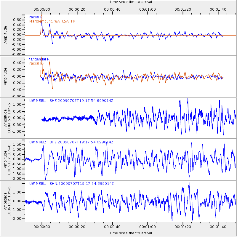
MRBL Marblemount, WA, USA - Earthquake Result Viewer
*The percent match for this event was below the threshold and hence no stack was calculated.
| Earthquake location: |
Baffin Bay |
| Earthquake latitude/longitude: |
75.4/-72.5 |
| Earthquake time(UTC): |
2009/07/07 (188) 19:11:46 GMT |
| Earthquake Depth: |
19 km |
| Earthquake Magnitude: |
5.9 MB, 5.7 MS, 6.1 MW, 6.0 MW |
| Earthquake Catalog/Contributor: |
WHDF/NEIC |
|
| Network: |
UW Pacific Northwest Regional Seismic Network |
| Station: |
MRBL Marblemount, WA, USA |
| Lat/Lon: |
48.52 N/121.48 W |
| Elevation: |
75 m |
|
| Distance: |
33.6 deg |
| Az: |
245.246 deg |
| Baz: |
20.34 deg |
| Ray Param: |
$rayparam |
*The percent match for this event was below the threshold and hence was not used in the summary stack. |
|
| Radial Match: |
77.47321 % |
| Radial Bump: |
400 |
| Transverse Match: |
67.37368 % |
| Transverse Bump: |
400 |
| SOD ConfigId: |
2648 |
| Insert Time: |
2010-02-27 04:53:12.498 +0000 |
| GWidth: |
2.5 |
| Max Bumps: |
400 |
| Tol: |
0.001 |
|
Signal To Noise
| Channel | StoN | STA | LTA |
| UW:MRBL: :BHZ:20090707T19:17:54.699014Z | 11.570939 | 1.0114908E-6 | 8.7416474E-8 |
| UW:MRBL: :BHN:20090707T19:17:54.699014Z | 6.286996 | 5.9136505E-7 | 9.4061626E-8 |
| UW:MRBL: :BHE:20090707T19:17:54.699014Z | 2.6432958 | 2.5754895E-7 | 9.743478E-8 |
| Arrivals |
| Ps | |
| PpPs | |
| PsPs/PpSs | |


