You are here: Home > Network List > TA - USArray Transportable Network (new EarthScope stations) Stations List
> Station G59A Clarenceville, QC, USA > Earthquake Result Viewer
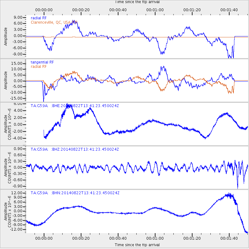
G59A Clarenceville, QC, USA - Earthquake Result Viewer
*The percent match for this event was below the threshold and hence no stack was calculated.
| Earthquake location: |
Iran-Iraq Border Region |
| Earthquake latitude/longitude: |
32.7/47.7 |
| Earthquake time(UTC): |
2014/08/22 (234) 13:29:18 GMT |
| Earthquake Depth: |
33 km |
| Earthquake Magnitude: |
5.0 mb |
| Earthquake Catalog/Contributor: |
ISC/ISC |
|
| Network: |
TA USArray Transportable Network (new EarthScope stations) |
| Station: |
G59A Clarenceville, QC, USA |
| Lat/Lon: |
45.08 N/73.18 W |
| Elevation: |
36 m |
|
| Distance: |
85.9 deg |
| Az: |
322.44 deg |
| Baz: |
46.539 deg |
| Ray Param: |
$rayparam |
*The percent match for this event was below the threshold and hence was not used in the summary stack. |
|
| Radial Match: |
23.962898 % |
| Radial Bump: |
354 |
| Transverse Match: |
35.38602 % |
| Transverse Bump: |
400 |
| SOD ConfigId: |
3390531 |
| Insert Time: |
2019-04-13 13:18:59.324 +0000 |
| GWidth: |
2.5 |
| Max Bumps: |
400 |
| Tol: |
0.001 |
|
Signal To Noise
| Channel | StoN | STA | LTA |
| TA:G59A: :BHZ:20140822T13:41:23.450024Z | 0.3265594 | 7.135644E-8 | 2.1850984E-7 |
| TA:G59A: :BHN:20140822T13:41:23.450024Z | 0.9619955 | 1.0196641E-5 | 1.0599469E-5 |
| TA:G59A: :BHE:20140822T13:41:23.450024Z | 1.2814101 | 3.4849659E-6 | 2.7196334E-6 |
| Arrivals |
| Ps | |
| PpPs | |
| PsPs/PpSs | |


