You are here: Home > Network List > TA - USArray Transportable Network (new EarthScope stations) Stations List
> Station O48A Farmland, IN, USA > Earthquake Result Viewer
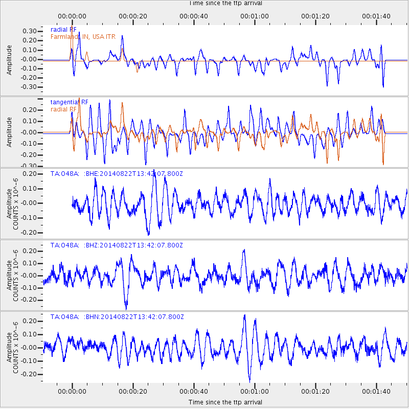
O48A Farmland, IN, USA - Earthquake Result Viewer
*The percent match for this event was below the threshold and hence no stack was calculated.
| Earthquake location: |
Iran-Iraq Border Region |
| Earthquake latitude/longitude: |
32.7/47.7 |
| Earthquake time(UTC): |
2014/08/22 (234) 13:29:18 GMT |
| Earthquake Depth: |
33 km |
| Earthquake Magnitude: |
5.0 mb |
| Earthquake Catalog/Contributor: |
ISC/ISC |
|
| Network: |
TA USArray Transportable Network (new EarthScope stations) |
| Station: |
O48A Farmland, IN, USA |
| Lat/Lon: |
40.26 N/85.16 W |
| Elevation: |
300 m |
|
| Distance: |
95.4 deg |
| Az: |
325.708 deg |
| Baz: |
38.394 deg |
| Ray Param: |
$rayparam |
*The percent match for this event was below the threshold and hence was not used in the summary stack. |
|
| Radial Match: |
50.247353 % |
| Radial Bump: |
400 |
| Transverse Match: |
47.085835 % |
| Transverse Bump: |
400 |
| SOD ConfigId: |
3390531 |
| Insert Time: |
2019-04-13 13:19:15.815 +0000 |
| GWidth: |
2.5 |
| Max Bumps: |
400 |
| Tol: |
0.001 |
|
Signal To Noise
| Channel | StoN | STA | LTA |
| TA:O48A: :BHZ:20140822T13:42:07.800Z | 0.6055949 | 4.1392507E-8 | 6.835016E-8 |
| TA:O48A: :BHN:20140822T13:42:07.800Z | 1.293576 | 7.612148E-8 | 5.8845774E-8 |
| TA:O48A: :BHE:20140822T13:42:07.800Z | 1.4626472 | 1.0060395E-7 | 6.87821E-8 |
| Arrivals |
| Ps | |
| PpPs | |
| PsPs/PpSs | |


