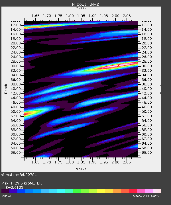
ZOU2 Zouf Plan - Earthquake Result Viewer

Earthquake location: Uganda
Earthquake latitude/longitude: 1.5/30.9
Earthquake time(UTC): 2013/07/03 (184) 19:21:45 GMT
Earthquake Depth: 10 km
Earthquake Magnitude: 5.7 MW, 5.7 MW, 5.7 MS, 5.8 MB
Earthquake Catalog/Contributor: NEIC PDE/NEIC PDE-W
Network: NI North-East Italy Broadband Network
Station: ZOU2 Zouf Plan
Lat/Lon: 46.56 N/12.97 E
Elevation: 1896 m
Distance: 47.5 deg
Az: 343.262 deg
Baz: 155.341 deg
Ray Param: 0.06995027
Estimated Moho Depth: 29.5 km
Estimated Crust Vp/Vs: 2.01
Assumed Crust Vp: 6.35 km/s
Estimated Crust Vs: 3.155 km/s
Estimated Crust Poisson's Ratio: 0.34
Radial Match: 86.90794 %
Radial Bump: 400
Transverse Match: 84.23424 %
Transverse Bump: 400
SOD ConfigId: 512894
Insert Time: 2013-09-15 14:10:19.033 +0000
GWidth: 2.5
Max Bumps: 400
Tol: 0.001

Signal To Noise

ChannelStoNSTALTA
NI:ZOU2: :HHZ:20130703T19:29:50.09801Z12.7177085.178684E-74.072026E-8
NI:ZOU2: :HHN:20130703T19:29:50.09801Z4.44976142.0779206E-74.6697348E-8
NI:ZOU2: :HHE:20130703T19:29:50.09801Z4.6870252.3576715E-75.0302088E-8
Arrivals
Ps5.0 SECOND
PpPs13 SECOND
PsPs/PpSs18 SECOND