You are here: Home > Network List > TJ - Tajikistan National Seismic Network Stations List
> Station CHGR Chuyangaron, Tajikistan > Earthquake Result Viewer
CHGR Chuyangaron, Tajikistan - Earthquake Result Viewer
| Earthquake location: |
Uganda |
| Earthquake latitude/longitude: |
1.5/30.9 |
| Earthquake time(UTC): |
2013/07/03 (184) 19:21:45 GMT |
| Earthquake Depth: |
10 km |
| Earthquake Magnitude: |
5.7 MW, 5.7 MW, 5.7 MS, 5.8 MB |
| Earthquake Catalog/Contributor: |
NEIC PDE/NEIC PDE-W |
|
| Network: |
TJ Tajikistan National Seismic Network |
| Station: |
CHGR Chuyangaron, Tajikistan |
| Lat/Lon: |
38.66 N/69.16 E |
| Elevation: |
1049 m |
|
| Distance: |
50.9 deg |
| Az: |
38.687 deg |
| Baz: |
232.946 deg |
| Ray Param: |
0.067769095 |
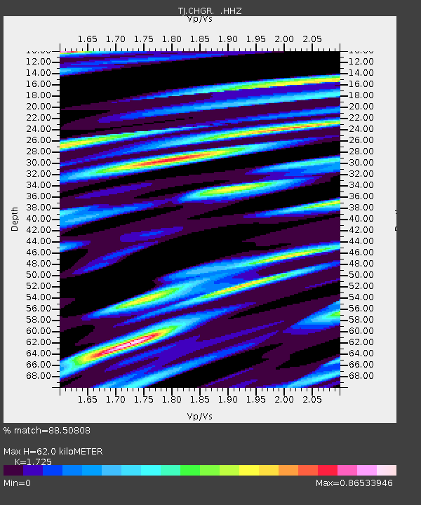
| Estimated Moho Depth: |
62.0 km |
| Estimated Crust Vp/Vs: |
1.73 |
| Assumed Crust Vp: |
6.483 km/s |
| Estimated Crust Vs: |
3.758 km/s |
| Estimated Crust Poisson's Ratio: |
0.25 |
|
| Radial Match: |
88.50808 % |
| Radial Bump: |
356 |
| Transverse Match: |
81.17594 % |
| Transverse Bump: |
400 |
| SOD ConfigId: |
512894 |
| Insert Time: |
2013-09-15 14:11:30.933 +0000 |
| GWidth: |
2.5 |
| Max Bumps: |
400 |
| Tol: |
0.001 |
|

Signal To Noise
| Channel | StoN | STA | LTA |
| TJ:CHGR: :HHZ:20130703T19:30:15.879993Z | 12.424053 | 1.6093329E-6 | 1.2953365E-7 |
| TJ:CHGR: :HHN:20130703T19:30:15.879993Z | 7.6418777 | 5.792268E-7 | 7.57964E-8 |
| TJ:CHGR: :HHE:20130703T19:30:15.879993Z | 11.628352 | 7.978392E-7 | 6.861155E-8 |
| Arrivals |
| Ps | 7.4 SECOND |
| PpPs | 25 SECOND |
| PsPs/PpSs | 32 SECOND |


