You are here: Home > Network List > TJ - Tajikistan National Seismic Network Stations List
> Station GARM Garm, Tajikistan > Earthquake Result Viewer
GARM Garm, Tajikistan - Earthquake Result Viewer
| Earthquake location: |
Uganda |
| Earthquake latitude/longitude: |
1.5/30.9 |
| Earthquake time(UTC): |
2013/07/03 (184) 19:21:45 GMT |
| Earthquake Depth: |
10 km |
| Earthquake Magnitude: |
5.7 MW, 5.7 MW, 5.7 MS, 5.8 MB |
| Earthquake Catalog/Contributor: |
NEIC PDE/NEIC PDE-W |
|
| Network: |
TJ Tajikistan National Seismic Network |
| Station: |
GARM Garm, Tajikistan |
| Lat/Lon: |
39.00 N/70.32 E |
| Elevation: |
1305 m |
|
| Distance: |
51.8 deg |
| Az: |
39.025 deg |
| Baz: |
233.88 deg |
| Ray Param: |
0.06717597 |
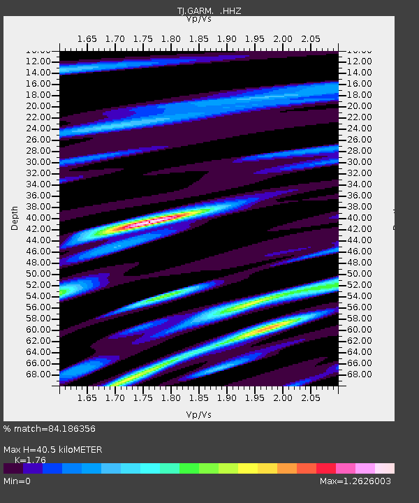
| Estimated Moho Depth: |
40.5 km |
| Estimated Crust Vp/Vs: |
1.76 |
| Assumed Crust Vp: |
6.306 km/s |
| Estimated Crust Vs: |
3.583 km/s |
| Estimated Crust Poisson's Ratio: |
0.26 |
|
| Radial Match: |
84.186356 % |
| Radial Bump: |
361 |
| Transverse Match: |
76.72505 % |
| Transverse Bump: |
400 |
| SOD ConfigId: |
512894 |
| Insert Time: |
2013-09-15 14:11:35.678 +0000 |
| GWidth: |
2.5 |
| Max Bumps: |
400 |
| Tol: |
0.001 |
|

Signal To Noise
| Channel | StoN | STA | LTA |
| TJ:GARM: :HHZ:20130703T19:30:22.830005Z | 11.177262 | 1.0447345E-6 | 9.346963E-8 |
| TJ:GARM: :HHN:20130703T19:30:22.830005Z | 3.178016 | 3.976012E-7 | 1.2510989E-7 |
| TJ:GARM: :HHE:20130703T19:30:22.830005Z | 3.9990745 | 3.9259425E-7 | 9.817128E-8 |
| Arrivals |
| Ps | 5.2 SECOND |
| PpPs | 17 SECOND |
| PsPs/PpSs | 22 SECOND |


