You are here: Home > Network List > CB - China National Seismic Network Stations List
> Station DL2 Dalian,Liaoning Province > Earthquake Result Viewer
DL2 Dalian,Liaoning Province - Earthquake Result Viewer
| Earthquake location: |
Solomon Islands |
| Earthquake latitude/longitude: |
-7.0/155.7 |
| Earthquake time(UTC): |
2013/07/04 (185) 17:15:54 GMT |
| Earthquake Depth: |
29 km |
| Earthquake Magnitude: |
6.1 MW, 5.7 MB, 6.0 MS, 6.1 MW |
| Earthquake Catalog/Contributor: |
NEIC PDE/NEIC PDE-W |
|
| Network: |
CB China National Seismic Network |
| Station: |
DL2 Dalian,Liaoning Province |
| Lat/Lon: |
38.91 N/121.63 E |
| Elevation: |
65 m |
|
| Distance: |
55.6 deg |
| Az: |
327.977 deg |
| Baz: |
137.579 deg |
| Ray Param: |
0.064653374 |
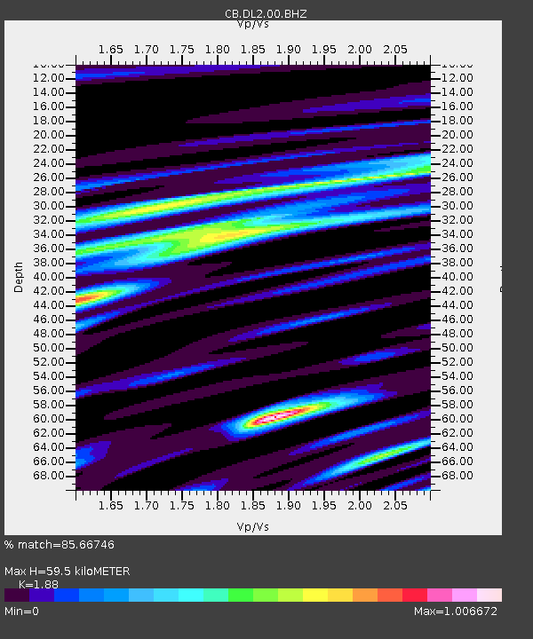
| Estimated Moho Depth: |
59.5 km |
| Estimated Crust Vp/Vs: |
1.88 |
| Assumed Crust Vp: |
6.134 km/s |
| Estimated Crust Vs: |
3.263 km/s |
| Estimated Crust Poisson's Ratio: |
0.30 |
|
| Radial Match: |
85.66746 % |
| Radial Bump: |
381 |
| Transverse Match: |
58.666004 % |
| Transverse Bump: |
400 |
| SOD ConfigId: |
512894 |
| Insert Time: |
2013-09-15 14:19:43.126 +0000 |
| GWidth: |
2.5 |
| Max Bumps: |
400 |
| Tol: |
0.001 |
|

Signal To Noise
| Channel | StoN | STA | LTA |
| CB:DL2:00:BHZ:20130704T17:24:56.540Z | 3.4638212 | 4.13806E-7 | 1.1946517E-7 |
| CB:DL2:00:BHN:20130704T17:24:56.540Z | 1.5010493 | 1.5997075E-7 | 1.0657262E-7 |
| CB:DL2:00:BHE:20130704T17:24:56.540Z | 1.6111875 | 1.8414654E-7 | 1.1429244E-7 |
| Arrivals |
| Ps | 8.9 SECOND |
| PpPs | 27 SECOND |
| PsPs/PpSs | 36 SECOND |


