You are here: Home > Network List > CB - China National Seismic Network Stations List
> Station TIA Taian,Shandong Province > Earthquake Result Viewer
TIA Taian,Shandong Province - Earthquake Result Viewer
| Earthquake location: |
Solomon Islands |
| Earthquake latitude/longitude: |
-7.0/155.7 |
| Earthquake time(UTC): |
2013/07/04 (185) 17:15:54 GMT |
| Earthquake Depth: |
29 km |
| Earthquake Magnitude: |
6.1 MW, 5.7 MB, 6.0 MS, 6.1 MW |
| Earthquake Catalog/Contributor: |
NEIC PDE/NEIC PDE-W |
|
| Network: |
CB China National Seismic Network |
| Station: |
TIA Taian,Shandong Province |
| Lat/Lon: |
36.21 N/117.12 E |
| Elevation: |
267 m |
|
| Distance: |
56.2 deg |
| Az: |
322.628 deg |
| Baz: |
131.843 deg |
| Ray Param: |
0.06422916 |
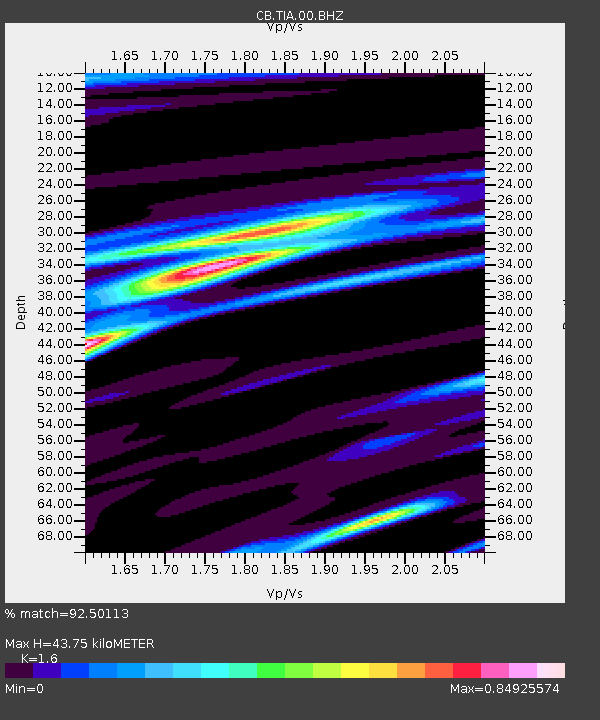
| Estimated Moho Depth: |
43.75 km |
| Estimated Crust Vp/Vs: |
1.60 |
| Assumed Crust Vp: |
6.363 km/s |
| Estimated Crust Vs: |
3.977 km/s |
| Estimated Crust Poisson's Ratio: |
0.18 |
|
| Radial Match: |
92.50113 % |
| Radial Bump: |
272 |
| Transverse Match: |
67.13884 % |
| Transverse Bump: |
400 |
| SOD ConfigId: |
512894 |
| Insert Time: |
2013-09-15 14:20:07.886 +0000 |
| GWidth: |
2.5 |
| Max Bumps: |
400 |
| Tol: |
0.001 |
|

Signal To Noise
| Channel | StoN | STA | LTA |
| CB:TIA:00:BHZ:20130704T17:25:01.209983Z | 5.755181 | 3.9557037E-7 | 6.8732916E-8 |
| CB:TIA:00:BHN:20130704T17:25:01.209983Z | 2.8866408 | 1.5719672E-7 | 5.4456628E-8 |
| CB:TIA:00:BHE:20130704T17:25:01.209983Z | 3.2786765 | 1.533706E-7 | 4.6778208E-8 |
| Arrivals |
| Ps | 4.4 SECOND |
| PpPs | 17 SECOND |
| PsPs/PpSs | 21 SECOND |


