You are here: Home > Network List > TA - USArray Transportable Network (new EarthScope stations) Stations List
> Station HDA Harding Lake, AK, USA > Earthquake Result Viewer
HDA Harding Lake, AK, USA - Earthquake Result Viewer
| Earthquake location: |
Solomon Islands |
| Earthquake latitude/longitude: |
-7.0/155.7 |
| Earthquake time(UTC): |
2013/07/04 (185) 17:15:54 GMT |
| Earthquake Depth: |
29 km |
| Earthquake Magnitude: |
6.1 MW, 5.7 MB, 6.0 MS, 6.1 MW |
| Earthquake Catalog/Contributor: |
NEIC PDE/NEIC PDE-W |
|
| Network: |
TA USArray Transportable Network (new EarthScope stations) |
| Station: |
HDA Harding Lake, AK, USA |
| Lat/Lon: |
64.41 N/146.95 W |
| Elevation: |
437 m |
|
| Distance: |
82.9 deg |
| Az: |
21.616 deg |
| Baz: |
237.345 deg |
| Ray Param: |
0.04651622 |
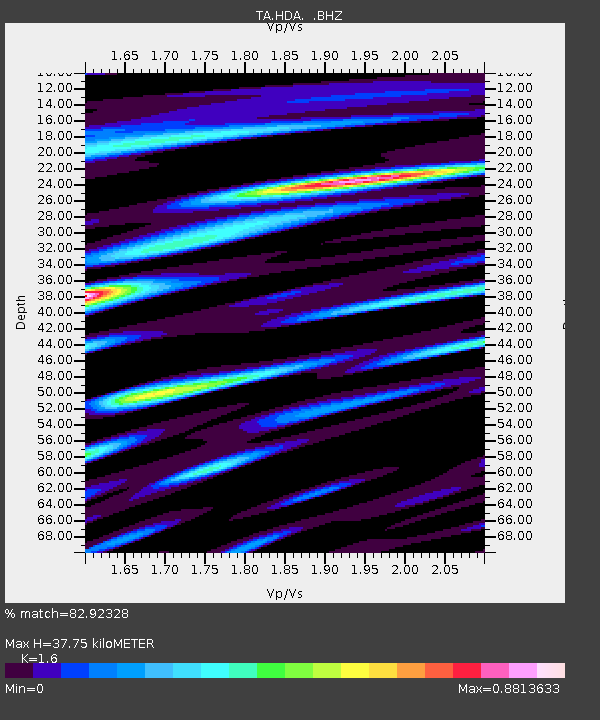
| Estimated Moho Depth: |
37.75 km |
| Estimated Crust Vp/Vs: |
1.60 |
| Assumed Crust Vp: |
6.566 km/s |
| Estimated Crust Vs: |
4.104 km/s |
| Estimated Crust Poisson's Ratio: |
0.18 |
|
| Radial Match: |
82.92328 % |
| Radial Bump: |
400 |
| Transverse Match: |
74.983696 % |
| Transverse Bump: |
400 |
| SOD ConfigId: |
512894 |
| Insert Time: |
2013-09-15 14:30:10.756 +0000 |
| GWidth: |
2.5 |
| Max Bumps: |
400 |
| Tol: |
0.001 |
|

Signal To Noise
| Channel | StoN | STA | LTA |
| TA:HDA: :BHZ:20130704T17:27:45.294028Z | 9.893842 | 3.896503E-7 | 3.9383117E-8 |
| TA:HDA: :BHN:20130704T17:27:45.294028Z | 3.3132699 | 1.0861096E-7 | 3.2780598E-8 |
| TA:HDA: :BHE:20130704T17:27:45.294028Z | 3.3287585 | 1.06403846E-7 | 3.1965023E-8 |
| Arrivals |
| Ps | 3.6 SECOND |
| PpPs | 15 SECOND |
| PsPs/PpSs | 18 SECOND |


