You are here: Home > Network List > US - United States National Seismic Network Stations List
> Station MSO Missoula, Montana, USA > Earthquake Result Viewer
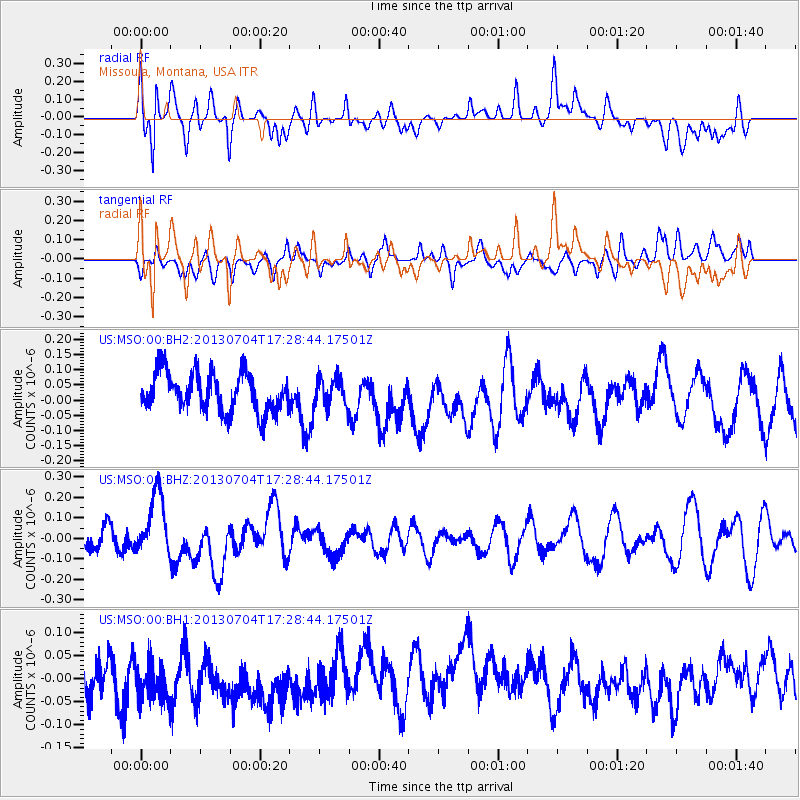
MSO Missoula, Montana, USA - Earthquake Result Viewer
*The percent match for this event was below the threshold and hence no stack was calculated.
| Earthquake location: |
Solomon Islands |
| Earthquake latitude/longitude: |
-7.0/155.7 |
| Earthquake time(UTC): |
2013/07/04 (185) 17:15:54 GMT |
| Earthquake Depth: |
29 km |
| Earthquake Magnitude: |
6.1 MW, 5.7 MB, 6.0 MS, 6.1 MW |
| Earthquake Catalog/Contributor: |
NEIC PDE/NEIC PDE-W |
|
| Network: |
US United States National Seismic Network |
| Station: |
MSO Missoula, Montana, USA |
| Lat/Lon: |
46.83 N/113.94 W |
| Elevation: |
1264 m |
|
| Distance: |
95.3 deg |
| Az: |
43.595 deg |
| Baz: |
265.435 deg |
| Ray Param: |
$rayparam |
*The percent match for this event was below the threshold and hence was not used in the summary stack. |
|
| Radial Match: |
54.353073 % |
| Radial Bump: |
400 |
| Transverse Match: |
45.023655 % |
| Transverse Bump: |
400 |
| SOD ConfigId: |
512894 |
| Insert Time: |
2013-09-15 14:32:09.683 +0000 |
| GWidth: |
2.5 |
| Max Bumps: |
400 |
| Tol: |
0.001 |
|
Signal To Noise
| Channel | StoN | STA | LTA |
| US:MSO:00:BHZ:20130704T17:28:44.17501Z | 3.1211832 | 1.5519007E-7 | 4.972155E-8 |
| US:MSO:00:BH1:20130704T17:28:44.17501Z | 1.2346712 | 5.2046083E-8 | 4.2153797E-8 |
| US:MSO:00:BH2:20130704T17:28:44.17501Z | 0.75353324 | 4.8534808E-8 | 6.440965E-8 |
| Arrivals |
| Ps | |
| PpPs | |
| PsPs/PpSs | |


