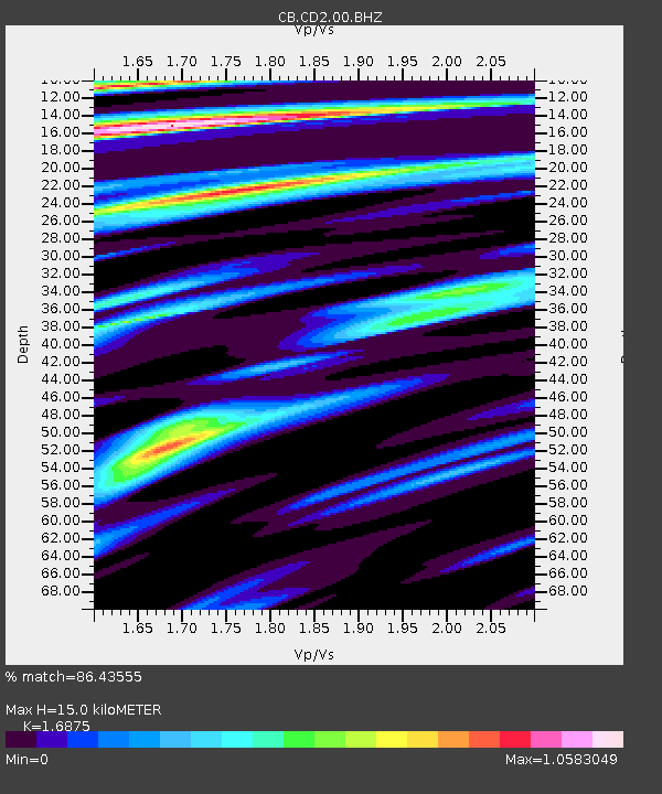
CD2 Chengdou,Sichuan Province - Earthquake Result Viewer

Earthquake location: Southern Sumatra, Indonesia
Earthquake latitude/longitude: -3.3/100.6
Earthquake time(UTC): 2013/07/06 (187) 05:05:06 GMT
Earthquake Depth: 21 km
Earthquake Magnitude: 6.0 MW, 5.9 MB, 6.0 MW, 6.3 MS
Earthquake Catalog/Contributor: NEIC PDE/NEIC PDE-W
Network: CB China National Seismic Network
Station: CD2 Chengdou,Sichuan Province
Lat/Lon: 30.91 N/103.76 E
Elevation: 653 m
Distance: 34.1 deg
Az: 4.897 deg
Baz: 185.69 deg
Ray Param: 0.077868074
Estimated Moho Depth: 15.0 km
Estimated Crust Vp/Vs: 1.69
Assumed Crust Vp: 6.159 km/s
Estimated Crust Vs: 3.65 km/s
Estimated Crust Poisson's Ratio: 0.23
Radial Match: 86.43555 %
Radial Bump: 400
Transverse Match: 70.41369 %
Transverse Bump: 400
SOD ConfigId: 512894
Insert Time: 2013-09-15 14:37:04.933 +0000
GWidth: 2.5
Max Bumps: 400
Tol: 0.001

Signal To Noise

ChannelStoNSTALTA
CB:CD2:00:BHZ:20130706T05:11:19.269995Z19.7108782.703599E-61.3716279E-7
CB:CD2:00:BHN:20130706T05:11:19.269995Z9.4375191.1712939E-61.2411036E-7
CB:CD2:00:BHE:20130706T05:11:19.269995Z2.82820632.5433272E-78.992722E-8
Arrivals
Ps1.8 SECOND
PpPs6.1 SECOND
PsPs/PpSs7.9 SECOND