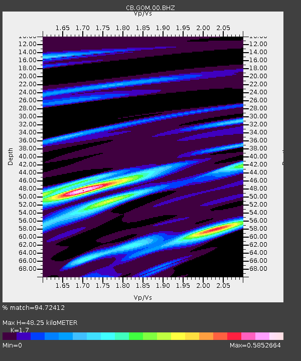
GOM Geermu,Qinghai Province - Earthquake Result Viewer

Earthquake location: Southern Sumatra, Indonesia
Earthquake latitude/longitude: -3.3/100.6
Earthquake time(UTC): 2013/07/06 (187) 05:05:06 GMT
Earthquake Depth: 21 km
Earthquake Magnitude: 6.0 MW, 5.9 MB, 6.0 MW, 6.3 MS
Earthquake Catalog/Contributor: NEIC PDE/NEIC PDE-W
Network: CB China National Seismic Network
Station: GOM Geermu,Qinghai Province
Lat/Lon: 36.20 N/94.81 E
Elevation: 3121 m
Distance: 39.6 deg
Az: 352.701 deg
Baz: 170.978 deg
Ray Param: 0.07484629
Estimated Moho Depth: 48.25 km
Estimated Crust Vp/Vs: 1.70
Assumed Crust Vp: 6.385 km/s
Estimated Crust Vs: 3.756 km/s
Estimated Crust Poisson's Ratio: 0.24
Radial Match: 94.72412 %
Radial Bump: 354
Transverse Match: 66.88408 %
Transverse Bump: 400
SOD ConfigId: 512894
Insert Time: 2013-09-15 14:37:12.697 +0000
GWidth: 2.5
Max Bumps: 400
Tol: 0.001

Signal To Noise

ChannelStoNSTALTA
CB:GOM:00:BHZ:20130706T05:12:05.989996Z35.416982.1063188E-65.9471997E-8
CB:GOM:00:BHN:20130706T05:12:05.989996Z32.323539.978969E-73.087215E-8
CB:GOM:00:BHE:20130706T05:12:05.989996Z3.46977578.308632E-82.3945733E-8
Arrivals
Ps5.7 SECOND
PpPs19 SECOND
PsPs/PpSs25 SECOND