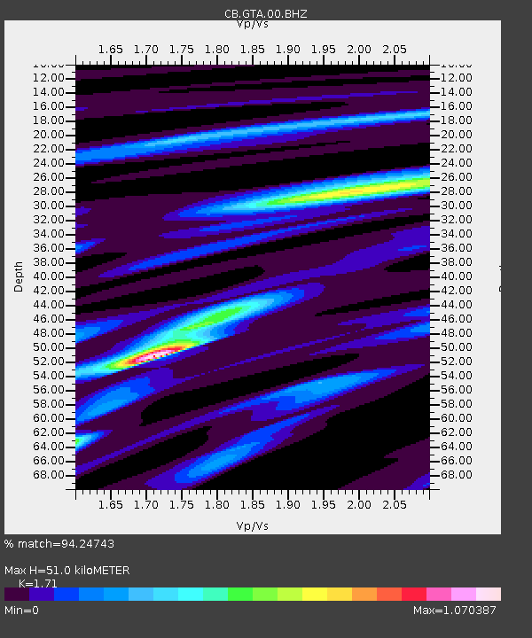
GTA Gaotai,Gansu Province - Earthquake Result Viewer

Earthquake location: Southern Sumatra, Indonesia
Earthquake latitude/longitude: -3.3/100.6
Earthquake time(UTC): 2013/07/06 (187) 05:05:06 GMT
Earthquake Depth: 21 km
Earthquake Magnitude: 6.0 MW, 5.9 MB, 6.0 MW, 6.3 MS
Earthquake Catalog/Contributor: NEIC PDE/NEIC PDE-W
Network: CB China National Seismic Network
Station: GTA Gaotai,Gansu Province
Lat/Lon: 39.40 N/99.82 E
Elevation: 1345 m
Distance: 42.5 deg
Az: 359.142 deg
Baz: 178.895 deg
Ray Param: 0.073132545
Estimated Moho Depth: 51.0 km
Estimated Crust Vp/Vs: 1.71
Assumed Crust Vp: 6.491 km/s
Estimated Crust Vs: 3.796 km/s
Estimated Crust Poisson's Ratio: 0.24
Radial Match: 94.24743 %
Radial Bump: 211
Transverse Match: 68.88264 %
Transverse Bump: 400
SOD ConfigId: 512894
Insert Time: 2013-09-15 14:37:13.131 +0000
GWidth: 2.5
Max Bumps: 400
Tol: 0.001

Signal To Noise

ChannelStoNSTALTA
CB:GTA:00:BHZ:20130706T05:12:29.290015Z52.312399.5243655E-71.8206713E-8
CB:GTA:00:BHN:20130706T05:12:29.290015Z31.942655.243412E-71.641508E-8
CB:GTA:00:BHE:20130706T05:12:29.290015Z2.7451124.364674E-81.5899804E-8
Arrivals
Ps6.0 SECOND
PpPs20 SECOND
PsPs/PpSs26 SECOND