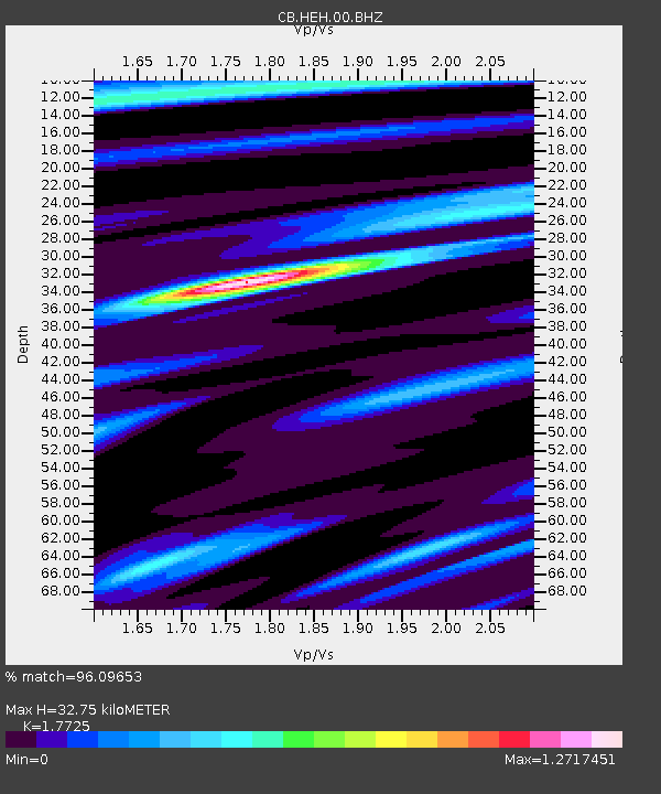
HEH Heihe,Heilongjiang Province - Earthquake Result Viewer
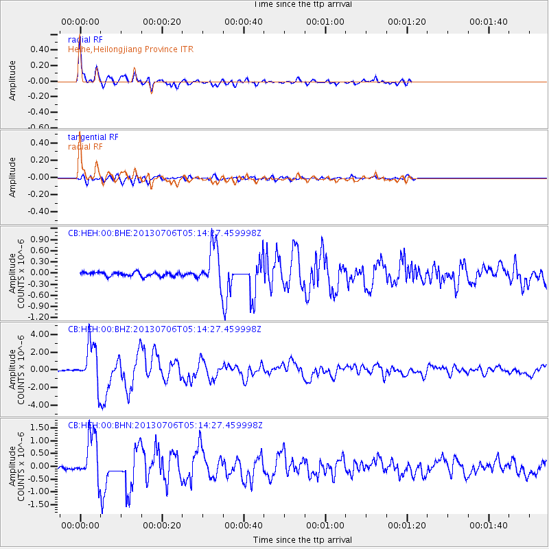
Earthquake location: Southern Sumatra, Indonesia
Earthquake latitude/longitude: -3.3/100.6
Earthquake time(UTC): 2013/07/06 (187) 05:05:06 GMT
Earthquake Depth: 21 km
Earthquake Magnitude: 6.0 MW, 5.9 MB, 6.0 MW, 6.3 MS
Earthquake Catalog/Contributor: NEIC PDE/NEIC PDE-W
Network: CB China National Seismic Network
Station: HEH Heihe,Heilongjiang Province
Lat/Lon: 50.25 N/127.41 E
Elevation: 165 m
Distance: 58.1 deg
Az: 19.966 deg
Baz: 212.077 deg
Ray Param: 0.063037254
Estimated Moho Depth: 32.75 km
Estimated Crust Vp/Vs: 1.77
Assumed Crust Vp: 6.419 km/s
Estimated Crust Vs: 3.622 km/s
Estimated Crust Poisson's Ratio: 0.27
Radial Match: 96.09653 %
Radial Bump: 400
Transverse Match: 72.81649 %
Transverse Bump: 400
SOD ConfigId: 512894
Insert Time: 2013-09-15 14:37:17.714 +0000
GWidth: 2.5
Max Bumps: 400
Tol: 0.001

Signal To Noise

ChannelStoNSTALTA
CB:HEH:00:BHZ:20130706T05:14:27.459998Z36.4468152.4204494E-66.641045E-8
CB:HEH:00:BHN:20130706T05:14:27.459998Z13.3885099.228011E-76.892486E-8
CB:HEH:00:BHE:20130706T05:14:27.459998Z10.5186395.730232E-75.4476942E-8
Arrivals
Ps4.1 SECOND
PpPs13 SECOND
PsPs/PpSs18 SECOND