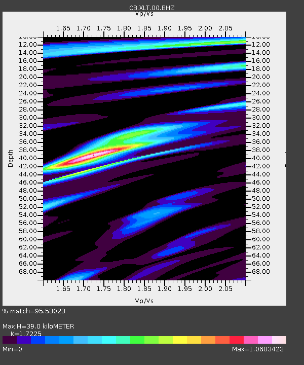
XLT Xilinhaote,Neimeng Province - Earthquake Result Viewer

Earthquake location: Southern Sumatra, Indonesia
Earthquake latitude/longitude: -3.3/100.6
Earthquake time(UTC): 2013/07/06 (187) 05:05:06 GMT
Earthquake Depth: 21 km
Earthquake Magnitude: 6.0 MW, 5.9 MB, 6.0 MW, 6.3 MS
Earthquake Catalog/Contributor: NEIC PDE/NEIC PDE-W
Network: CB China National Seismic Network
Station: XLT Xilinhaote,Neimeng Province
Lat/Lon: 43.90 N/116.08 E
Elevation: 1030 m
Distance: 49.0 deg
Az: 14.849 deg
Baz: 200.729 deg
Ray Param: 0.068967886
Estimated Moho Depth: 39.0 km
Estimated Crust Vp/Vs: 1.72
Assumed Crust Vp: 6.459 km/s
Estimated Crust Vs: 3.75 km/s
Estimated Crust Poisson's Ratio: 0.25
Radial Match: 95.53023 %
Radial Bump: 295
Transverse Match: 72.49451 %
Transverse Bump: 400
SOD ConfigId: 512894
Insert Time: 2013-09-15 14:37:37.969 +0000
GWidth: 2.5
Max Bumps: 400
Tol: 0.001

Signal To Noise

ChannelStoNSTALTA
CB:XLT:00:BHZ:20130706T05:13:20.709998Z25.5505662.3842988E-69.3316864E-8
CB:XLT:00:BHN:20130706T05:13:20.709998Z14.3131071.246324E-68.707572E-8
CB:XLT:00:BHE:20130706T05:13:20.709998Z7.33539156.068349E-78.272699E-8
Arrivals
Ps4.6 SECOND
PpPs15 SECOND
PsPs/PpSs20 SECOND