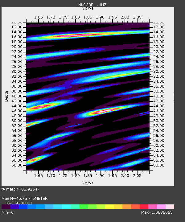
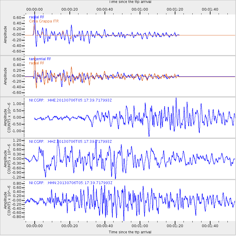
CGRP Cima Grappa - Earthquake Result Viewer

Earthquake location: Southern Sumatra, Indonesia
Earthquake latitude/longitude: -3.3/100.6
Earthquake time(UTC): 2013/07/06 (187) 05:05:06 GMT
Earthquake Depth: 21 km
Earthquake Magnitude: 6.0 MW, 5.9 MB, 6.0 MW, 6.3 MS
Earthquake Catalog/Contributor: NEIC PDE/NEIC PDE-W
Network: NI North-East Italy Broadband Network
Station: CGRP Cima Grappa
Lat/Lon: 45.88 N/11.80 E
Elevation: 1757 m
Distance: 91.5 deg
Az: 315.683 deg
Baz: 93.156 deg
Ray Param: 0.041598897
Estimated Moho Depth: 45.75 km
Estimated Crust Vp/Vs: 1.92
Assumed Crust Vp: 6.155 km/s
Estimated Crust Vs: 3.206 km/s
Estimated Crust Poisson's Ratio: 0.31
Radial Match: 85.92547 %
Radial Bump: 400
Transverse Match: 82.71159 %
Transverse Bump: 400
SOD ConfigId: 512894
Insert Time: 2013-09-15 14:44:38.137 +0000
GWidth: 2.5
Max Bumps: 400
Tol: 0.001

Signal To Noise

ChannelStoNSTALTA
NI:CGRP: :HHZ:20130706T05:17:39.717993Z4.46657133.6861215E-78.252687E-8
NI:CGRP: :HHN:20130706T05:17:39.717993Z1.02960778.007298E-87.777038E-8
NI:CGRP: :HHE:20130706T05:17:39.717993Z3.20929862.4476844E-77.626851E-8
Arrivals
Ps7.0 SECOND
PpPs21 SECOND
PsPs/PpSs28 SECOND