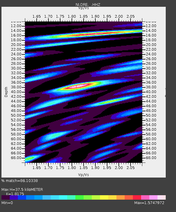
DRE Drenchia - Earthquake Result Viewer

Earthquake location: Southern Sumatra, Indonesia
Earthquake latitude/longitude: -3.3/100.6
Earthquake time(UTC): 2013/07/06 (187) 05:05:06 GMT
Earthquake Depth: 21 km
Earthquake Magnitude: 6.0 MW, 5.9 MB, 6.0 MW, 6.3 MS
Earthquake Catalog/Contributor: NEIC PDE/NEIC PDE-W
Network: NI North-East Italy Broadband Network
Station: DRE Drenchia
Lat/Lon: 46.17 N/13.65 E
Elevation: 810 m
Distance: 90.2 deg
Az: 316.061 deg
Baz: 94.471 deg
Ray Param: 0.04168875
Estimated Moho Depth: 37.5 km
Estimated Crust Vp/Vs: 1.82
Assumed Crust Vp: 6.35 km/s
Estimated Crust Vs: 3.494 km/s
Estimated Crust Poisson's Ratio: 0.28
Radial Match: 86.10338 %
Radial Bump: 400
Transverse Match: 82.91628 %
Transverse Bump: 400
SOD ConfigId: 512894
Insert Time: 2013-09-15 14:44:47.674 +0000
GWidth: 2.5
Max Bumps: 400
Tol: 0.001

Signal To Noise

ChannelStoNSTALTA
NI:DRE: :HHZ:20130706T05:17:33.897986Z2.86093953.6247363E-71.2669742E-7
NI:DRE: :HHN:20130706T05:17:33.897986Z0.76113215.349205E-87.027959E-8
NI:DRE: :HHE:20130706T05:17:33.897986Z2.28809021.3723454E-75.9977765E-8
Arrivals
Ps4.9 SECOND
PpPs16 SECOND
PsPs/PpSs21 SECOND