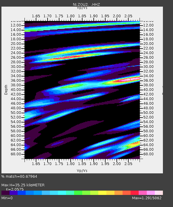
ZOU2 Zouf Plan - Earthquake Result Viewer

Earthquake location: Southern Sumatra, Indonesia
Earthquake latitude/longitude: -3.3/100.6
Earthquake time(UTC): 2013/07/06 (187) 05:05:06 GMT
Earthquake Depth: 21 km
Earthquake Magnitude: 6.0 MW, 5.9 MB, 6.0 MW, 6.3 MS
Earthquake Catalog/Contributor: NEIC PDE/NEIC PDE-W
Network: NI North-East Italy Broadband Network
Station: ZOU2 Zouf Plan
Lat/Lon: 46.56 N/12.97 E
Elevation: 1896 m
Distance: 90.7 deg
Az: 316.41 deg
Baz: 93.984 deg
Ray Param: 0.041653667
Estimated Moho Depth: 35.25 km
Estimated Crust Vp/Vs: 2.06
Assumed Crust Vp: 6.35 km/s
Estimated Crust Vs: 3.086 km/s
Estimated Crust Poisson's Ratio: 0.35
Radial Match: 80.67964 %
Radial Bump: 400
Transverse Match: 75.28823 %
Transverse Bump: 400
SOD ConfigId: 512894
Insert Time: 2013-09-15 14:44:58.935 +0000
GWidth: 2.5
Max Bumps: 400
Tol: 0.001

Signal To Noise

ChannelStoNSTALTA
NI:ZOU2: :HHZ:20130706T05:17:36.168005Z5.7546683.6622777E-76.3640115E-8
NI:ZOU2: :HHN:20130706T05:17:36.168005Z1.25018111.3095027E-71.0474505E-7
NI:ZOU2: :HHE:20130706T05:17:36.168005Z1.42346371.2746652E-78.954673E-8
Arrivals
Ps6.0 SECOND
PpPs17 SECOND
PsPs/PpSs23 SECOND