You are here: Home > Network List > AU - Australian Seismological Centre Stations List
> Station PSAC2 Pilbara Seismic Array Element C2 > Earthquake Result Viewer
PSAC2 Pilbara Seismic Array Element C2 - Earthquake Result Viewer
| Earthquake location: |
New Ireland Region, P.N.G. |
| Earthquake latitude/longitude: |
-3.9/153.9 |
| Earthquake time(UTC): |
2013/07/07 (188) 18:35:30 GMT |
| Earthquake Depth: |
386 km |
| Earthquake Magnitude: |
7.3 MW, 6.5 MB, 7.3 MW |
| Earthquake Catalog/Contributor: |
NEIC PDE/NEIC PDE-W |
|
| Network: |
AU Australian Seismological Centre |
| Station: |
PSAC2 Pilbara Seismic Array Element C2 |
| Lat/Lon: |
21.56 S/119.90 E |
| Elevation: |
330 m |
|
| Distance: |
37.4 deg |
| Az: |
239.064 deg |
| Baz: |
66.828 deg |
| Ray Param: |
0.07448658 |
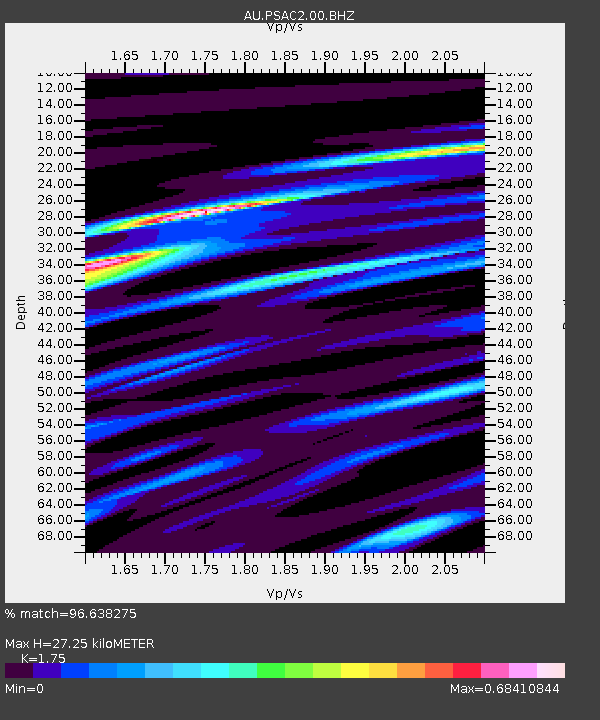
| Estimated Moho Depth: |
27.25 km |
| Estimated Crust Vp/Vs: |
1.75 |
| Assumed Crust Vp: |
6.464 km/s |
| Estimated Crust Vs: |
3.693 km/s |
| Estimated Crust Poisson's Ratio: |
0.26 |
|
| Radial Match: |
96.638275 % |
| Radial Bump: |
272 |
| Transverse Match: |
75.971085 % |
| Transverse Bump: |
400 |
| SOD ConfigId: |
512894 |
| Insert Time: |
2013-09-15 14:51:37.166 +0000 |
| GWidth: |
2.5 |
| Max Bumps: |
400 |
| Tol: |
0.001 |
|

Signal To Noise
| Channel | StoN | STA | LTA |
| AU:PSAC2:00:BHZ:20130707T18:41:38.018992Z | 7.739199 | 2.3139528E-6 | 2.9899124E-7 |
| AU:PSAC2:00:BH1:20130707T18:41:38.018992Z | 3.0356283 | 9.365378E-7 | 3.085153E-7 |
| AU:PSAC2:00:BH2:20130707T18:41:38.018992Z | 0.8749186 | 2.2244006E-7 | 2.542409E-7 |
| Arrivals |
| Ps | 3.4 SECOND |
| PpPs | 11 SECOND |
| PsPs/PpSs | 14 SECOND |


