You are here: Home > Network List > GT - Global Telemetered Seismograph Network (USAF/USGS) Stations List
> Station VNDA Wright Valley (Bull Pass) Antarctica > Earthquake Result Viewer
VNDA Wright Valley (Bull Pass) Antarctica - Earthquake Result Viewer
| Earthquake location: |
New Ireland Region, P.N.G. |
| Earthquake latitude/longitude: |
-3.9/153.9 |
| Earthquake time(UTC): |
2013/07/07 (188) 18:35:30 GMT |
| Earthquake Depth: |
386 km |
| Earthquake Magnitude: |
7.3 MW, 6.5 MB, 7.3 MW |
| Earthquake Catalog/Contributor: |
NEIC PDE/NEIC PDE-W |
|
| Network: |
GT Global Telemetered Seismograph Network (USAF/USGS) |
| Station: |
VNDA Wright Valley (Bull Pass) Antarctica |
| Lat/Lon: |
77.52 S/161.85 E |
| Elevation: |
151 m |
|
| Distance: |
73.7 deg |
| Az: |
178.209 deg |
| Baz: |
351.758 deg |
| Ray Param: |
0.051706895 |
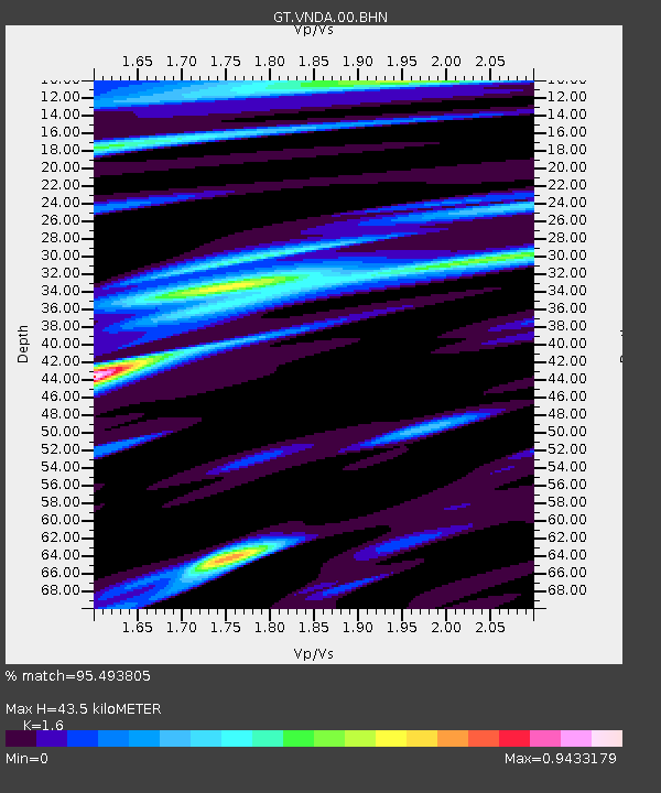
| Estimated Moho Depth: |
43.5 km |
| Estimated Crust Vp/Vs: |
1.60 |
| Assumed Crust Vp: |
6.245 km/s |
| Estimated Crust Vs: |
3.903 km/s |
| Estimated Crust Poisson's Ratio: |
0.18 |
|
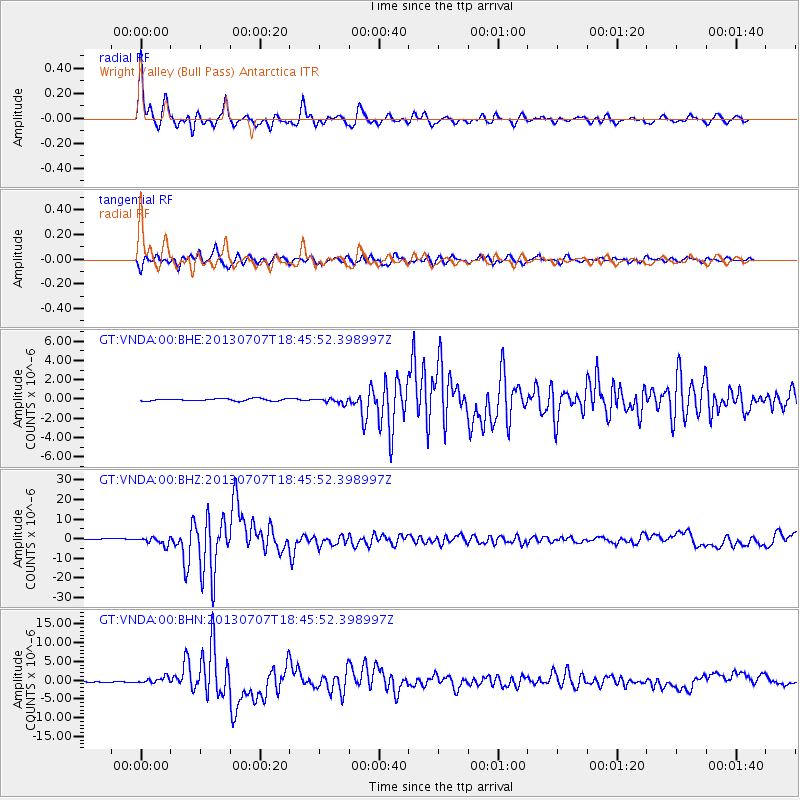
| Radial Match: |
95.493805 % |
| Radial Bump: |
400 |
| Transverse Match: |
90.32126 % |
| Transverse Bump: |
400 |
| SOD ConfigId: |
512894 |
| Insert Time: |
2013-09-15 14:57:33.542 +0000 |
| GWidth: |
2.5 |
| Max Bumps: |
400 |
| Tol: |
0.001 |
|
Signal To Noise
| Channel | StoN | STA | LTA |
| GT:VNDA:00:BHZ:20130707T18:45:52.398997Z | 9.262459 | 1.9672123E-6 | 2.1238554E-7 |
| GT:VNDA:00:BHN:20130707T18:45:52.398997Z | 6.755051 | 7.927139E-7 | 1.17351284E-7 |
| GT:VNDA:00:BHE:20130707T18:45:52.398997Z | 2.4640868 | 2.7737957E-7 | 1.1256892E-7 |
| Arrivals |
| Ps | 4.3 SECOND |
| PpPs | 18 SECOND |
| PsPs/PpSs | 22 SECOND |


