You are here: Home > Network List > II - Global Seismograph Network (GSN - IRIS/IDA) Stations List
> Station KAPI Kappang, Sulawesi, Indonesia > Earthquake Result Viewer
KAPI Kappang, Sulawesi, Indonesia - Earthquake Result Viewer
| Earthquake location: |
New Ireland Region, P.N.G. |
| Earthquake latitude/longitude: |
-3.9/153.9 |
| Earthquake time(UTC): |
2013/07/07 (188) 18:35:30 GMT |
| Earthquake Depth: |
386 km |
| Earthquake Magnitude: |
7.3 MW, 6.5 MB, 7.3 MW |
| Earthquake Catalog/Contributor: |
NEIC PDE/NEIC PDE-W |
|
| Network: |
II Global Seismograph Network (GSN - IRIS/IDA) |
| Station: |
KAPI Kappang, Sulawesi, Indonesia |
| Lat/Lon: |
5.01 S/119.75 E |
| Elevation: |
300 m |
|
| Distance: |
34.1 deg |
| Az: |
266.86 deg |
| Baz: |
89.584 deg |
| Ray Param: |
0.07631941 |
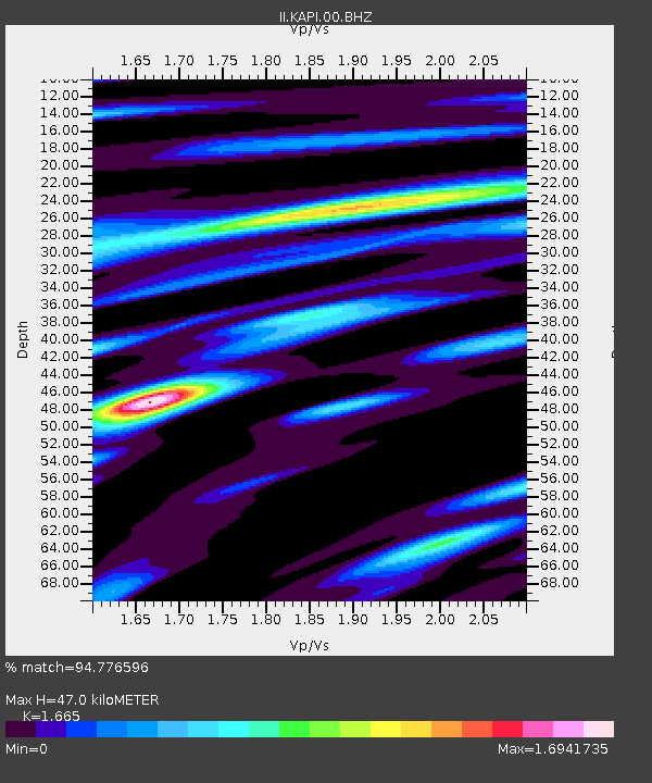
| Estimated Moho Depth: |
47.0 km |
| Estimated Crust Vp/Vs: |
1.66 |
| Assumed Crust Vp: |
6.343 km/s |
| Estimated Crust Vs: |
3.81 km/s |
| Estimated Crust Poisson's Ratio: |
0.22 |
|
| Radial Match: |
94.776596 % |
| Radial Bump: |
309 |
| Transverse Match: |
63.42795 % |
| Transverse Bump: |
400 |
| SOD ConfigId: |
512894 |
| Insert Time: |
2013-09-15 14:59:20.484 +0000 |
| GWidth: |
2.5 |
| Max Bumps: |
400 |
| Tol: |
0.001 |
|
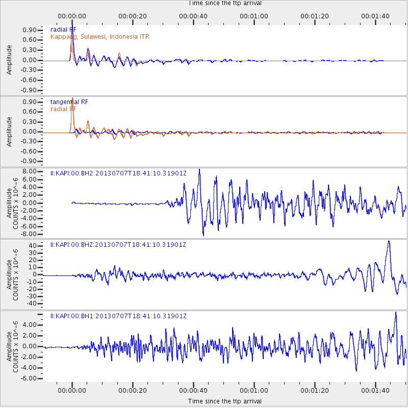
Signal To Noise
| Channel | StoN | STA | LTA |
| II:KAPI:00:BHZ:20130707T18:41:10.31901Z | 13.152937 | 1.024105E-6 | 7.786132E-8 |
| II:KAPI:00:BH1:20130707T18:41:10.31901Z | 2.319879 | 1.4021542E-7 | 6.044083E-8 |
| II:KAPI:00:BH2:20130707T18:41:10.31901Z | 4.1168413 | 4.7750837E-7 | 1.15989E-7 |
| Arrivals |
| Ps | 5.3 SECOND |
| PpPs | 18 SECOND |
| PsPs/PpSs | 24 SECOND |


