You are here: Home > Network List > TA - USArray Transportable Network (new EarthScope stations) Stations List
> Station B05D Stanwood, WA, USA > Earthquake Result Viewer
B05D Stanwood, WA, USA - Earthquake Result Viewer
| Earthquake location: |
New Ireland Region, P.N.G. |
| Earthquake latitude/longitude: |
-3.9/153.9 |
| Earthquake time(UTC): |
2013/07/07 (188) 18:35:30 GMT |
| Earthquake Depth: |
386 km |
| Earthquake Magnitude: |
7.3 MW, 6.5 MB, 7.3 MW |
| Earthquake Catalog/Contributor: |
NEIC PDE/NEIC PDE-W |
|
| Network: |
TA USArray Transportable Network (new EarthScope stations) |
| Station: |
B05D Stanwood, WA, USA |
| Lat/Lon: |
48.26 N/122.10 W |
| Elevation: |
153 m |
|
| Distance: |
88.9 deg |
| Az: |
41.653 deg |
| Baz: |
262.92 deg |
| Ray Param: |
0.041689653 |
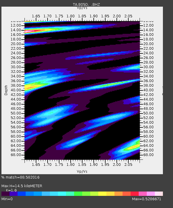
| Estimated Moho Depth: |
14.5 km |
| Estimated Crust Vp/Vs: |
1.60 |
| Assumed Crust Vp: |
6.566 km/s |
| Estimated Crust Vs: |
4.104 km/s |
| Estimated Crust Poisson's Ratio: |
0.18 |
|
| Radial Match: |
88.582016 % |
| Radial Bump: |
400 |
| Transverse Match: |
68.903786 % |
| Transverse Bump: |
400 |
| SOD ConfigId: |
512894 |
| Insert Time: |
2013-09-15 15:05:52.858 +0000 |
| GWidth: |
2.5 |
| Max Bumps: |
400 |
| Tol: |
0.001 |
|

Signal To Noise
| Channel | StoN | STA | LTA |
| TA:B05D: :BHZ:20130707T18:47:11.049998Z | 4.4895587 | 5.2139444E-7 | 1.16134906E-7 |
| TA:B05D: :BHN:20130707T18:47:11.049998Z | 1.5326933 | 1.389955E-7 | 9.06871E-8 |
| TA:B05D: :BHE:20130707T18:47:11.049998Z | 1.4455417 | 1.7169383E-7 | 1.1877472E-7 |
| Arrivals |
| Ps | 1.4 SECOND |
| PpPs | 5.6 SECOND |
| PsPs/PpSs | 7.0 SECOND |


