You are here: Home > Network List > TA - USArray Transportable Network (new EarthScope stations) Stations List
> Station F05D White Salmon, WA, USA > Earthquake Result Viewer
F05D White Salmon, WA, USA - Earthquake Result Viewer

| Earthquake location: |
New Ireland Region, P.N.G. |
| Earthquake latitude/longitude: |
-3.9/153.9 |
| Earthquake time(UTC): |
2013/07/07 (188) 18:35:30 GMT |
| Earthquake Depth: |
386 km |
| Earthquake Magnitude: |
7.3 MW, 6.5 MB, 7.3 MW |
| Earthquake Catalog/Contributor: |
NEIC PDE/NEIC PDE-W |
|
| Network: |
TA USArray Transportable Network (new EarthScope stations) |
| Station: |
F05D White Salmon, WA, USA |
| Lat/Lon: |
45.89 N/121.46 W |
| Elevation: |
472 m |
|
| Distance: |
89.0 deg |
| Az: |
44.069 deg |
| Baz: |
263.429 deg |
| Ray Param: |
0.04167905 |
| Estimated Moho Depth: |
30.5 km |
| Estimated Crust Vp/Vs: |
1.61 |
| Assumed Crust Vp: |
6.597 km/s |
| Estimated Crust Vs: |
4.091 km/s |
| Estimated Crust Poisson's Ratio: |
0.19 |
|
| Radial Match: |
87.8088 % |
| Radial Bump: |
400 |
| Transverse Match: |
81.10063 % |
| Transverse Bump: |
400 |
| SOD ConfigId: |
512894 |
| Insert Time: |
2013-09-15 15:06:17.494 +0000 |
| GWidth: |
2.5 |
| Max Bumps: |
400 |
| Tol: |
0.001 |
|
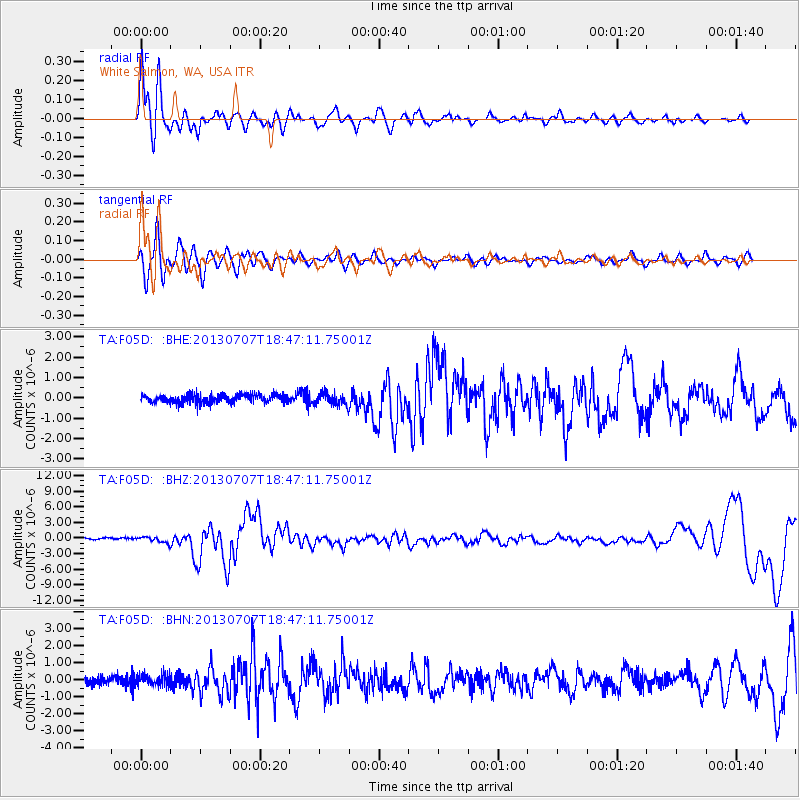
Signal To Noise
| Channel | StoN | STA | LTA |
| TA:F05D: :BHZ:20130707T18:47:11.75001Z | 2.380554 | 5.4411584E-7 | 2.2856692E-7 |
| TA:F05D: :BHN:20130707T18:47:11.75001Z | 1.3353025 | 3.584034E-7 | 2.6840615E-7 |
| TA:F05D: :BHE:20130707T18:47:11.75001Z | 1.46906 | 3.046774E-7 | 2.0739617E-7 |
| Arrivals |
| Ps | 2.9 SECOND |
| PpPs | 12 SECOND |
| PsPs/PpSs | 15 SECOND |


