You are here: Home > Network List > TA - USArray Transportable Network (new EarthScope stations) Stations List
> Station TPFO Pinon Flats, CA, USA > Earthquake Result Viewer
TPFO Pinon Flats, CA, USA - Earthquake Result Viewer
| Earthquake location: |
New Ireland Region, P.N.G. |
| Earthquake latitude/longitude: |
-3.9/153.9 |
| Earthquake time(UTC): |
2013/07/07 (188) 18:35:30 GMT |
| Earthquake Depth: |
386 km |
| Earthquake Magnitude: |
7.3 MW, 6.5 MB, 7.3 MW |
| Earthquake Catalog/Contributor: |
NEIC PDE/NEIC PDE-W |
|
| Network: |
TA USArray Transportable Network (new EarthScope stations) |
| Station: |
TPFO Pinon Flats, CA, USA |
| Lat/Lon: |
33.61 N/116.45 W |
| Elevation: |
1275 m |
|
| Distance: |
91.8 deg |
| Az: |
56.613 deg |
| Baz: |
266.542 deg |
| Ray Param: |
0.041320402 |
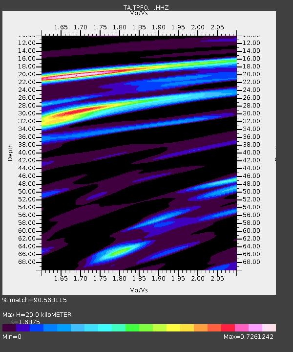
| Estimated Moho Depth: |
20.0 km |
| Estimated Crust Vp/Vs: |
1.69 |
| Assumed Crust Vp: |
6.264 km/s |
| Estimated Crust Vs: |
3.712 km/s |
| Estimated Crust Poisson's Ratio: |
0.23 |
|
| Radial Match: |
90.568115 % |
| Radial Bump: |
400 |
| Transverse Match: |
73.036064 % |
| Transverse Bump: |
400 |
| SOD ConfigId: |
512894 |
| Insert Time: |
2013-09-15 15:07:30.378 +0000 |
| GWidth: |
2.5 |
| Max Bumps: |
400 |
| Tol: |
0.001 |
|
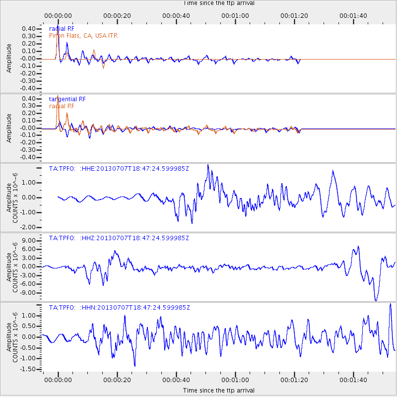
Signal To Noise
| Channel | StoN | STA | LTA |
| TA:TPFO: :HHZ:20130707T18:47:24.599985Z | 1.8171011 | 3.6741187E-7 | 2.0219672E-7 |
| TA:TPFO: :HHN:20130707T18:47:24.599985Z | 0.9001814 | 1.2404068E-7 | 1.3779521E-7 |
| TA:TPFO: :HHE:20130707T18:47:24.599985Z | 1.8919673 | 1.8264086E-7 | 9.653489E-8 |
| Arrivals |
| Ps | 2.2 SECOND |
| PpPs | 8.4 SECOND |
| PsPs/PpSs | 11 SECOND |


