You are here: Home > Network List > UU - University of Utah Regional Network Stations List
> Station PKCU Pink Cliffs, UT, USA > Earthquake Result Viewer
PKCU Pink Cliffs, UT, USA - Earthquake Result Viewer
| Earthquake location: |
New Ireland Region, P.N.G. |
| Earthquake latitude/longitude: |
-3.9/153.9 |
| Earthquake time(UTC): |
2013/07/07 (188) 18:35:30 GMT |
| Earthquake Depth: |
386 km |
| Earthquake Magnitude: |
7.3 MW, 6.5 MB, 7.3 MW |
| Earthquake Catalog/Contributor: |
NEIC PDE/NEIC PDE-W |
|
| Network: |
UU University of Utah Regional Network |
| Station: |
PKCU Pink Cliffs, UT, USA |
| Lat/Lon: |
37.44 N/112.31 W |
| Elevation: |
2834 m |
|
| Distance: |
95.3 deg |
| Az: |
52.908 deg |
| Baz: |
269.173 deg |
| Ray Param: |
0.04045879 |
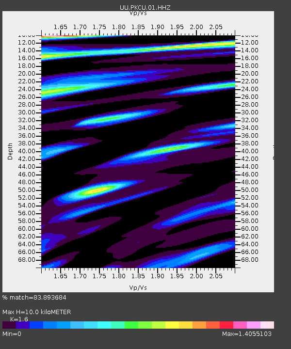
| Estimated Moho Depth: |
10.0 km |
| Estimated Crust Vp/Vs: |
1.60 |
| Assumed Crust Vp: |
6.194 km/s |
| Estimated Crust Vs: |
3.871 km/s |
| Estimated Crust Poisson's Ratio: |
0.18 |
|
| Radial Match: |
83.893684 % |
| Radial Bump: |
380 |
| Transverse Match: |
62.656513 % |
| Transverse Bump: |
400 |
| SOD ConfigId: |
512894 |
| Insert Time: |
2013-09-15 15:09:18.254 +0000 |
| GWidth: |
2.5 |
| Max Bumps: |
400 |
| Tol: |
0.001 |
|

Signal To Noise
| Channel | StoN | STA | LTA |
| UU:PKCU:01:HHZ:20130707T18:47:40.599985Z | 2.4222696 | 1.0815412E-8 | 4.464991E-9 |
| UU:PKCU:01:HHN:20130707T18:47:40.599985Z | 0.5028228 | 2.8029263E-9 | 5.5743814E-9 |
| UU:PKCU:01:HHE:20130707T18:47:40.599985Z | 2.2774253 | 1.2222983E-8 | 5.367018E-9 |
| Arrivals |
| Ps | 1.0 SECOND |
| PpPs | 4.1 SECOND |
| PsPs/PpSs | 5.1 SECOND |


