You are here: Home > Network List > UW - Pacific Northwest Regional Seismic Network Stations List
> Station PASS Maple Falls, WA, USA > Earthquake Result Viewer
PASS Maple Falls, WA, USA - Earthquake Result Viewer
| Earthquake location: |
New Ireland Region, P.N.G. |
| Earthquake latitude/longitude: |
-3.9/153.9 |
| Earthquake time(UTC): |
2013/07/07 (188) 18:35:30 GMT |
| Earthquake Depth: |
386 km |
| Earthquake Magnitude: |
7.3 MW, 6.5 MB, 7.3 MW |
| Earthquake Catalog/Contributor: |
NEIC PDE/NEIC PDE-W |
|
| Network: |
UW Pacific Northwest Regional Seismic Network |
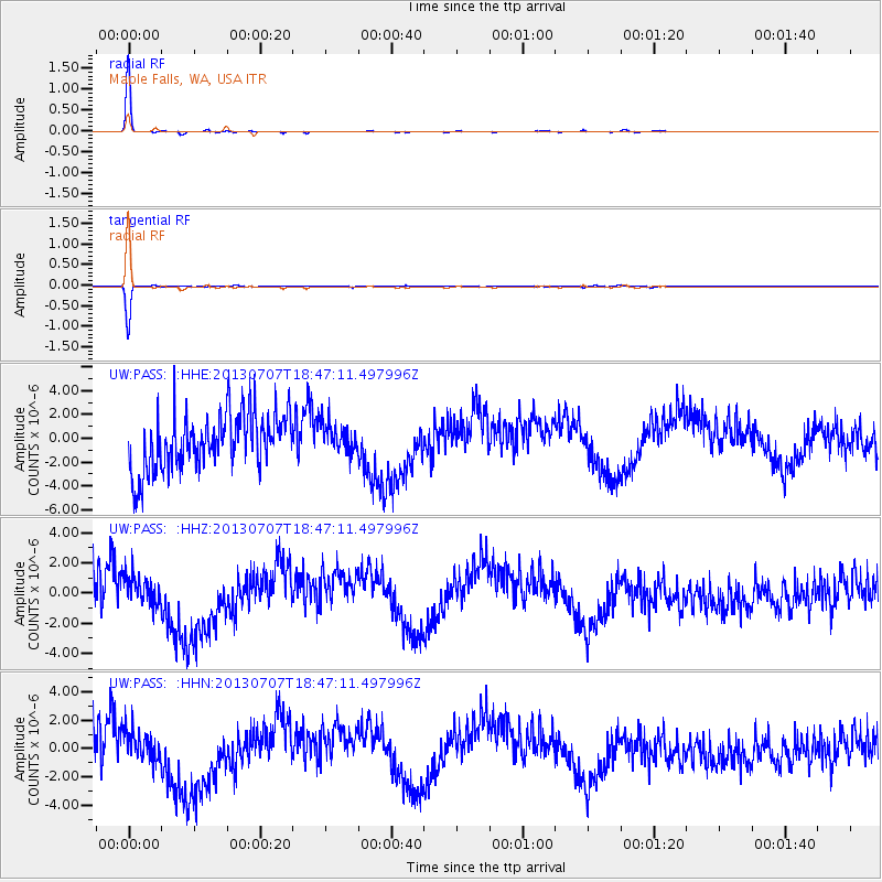
| Station: |
PASS Maple Falls, WA, USA |
| Lat/Lon: |
49.00 N/122.09 W |
| Elevation: |
174 m |
|
| Distance: |
89.0 deg |
| Az: |
40.925 deg |
| Baz: |
262.915 deg |
| Ray Param: |
0.0416827 |
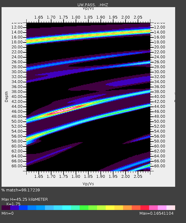
| Estimated Moho Depth: |
45.25 km |
| Estimated Crust Vp/Vs: |
1.75 |
| Assumed Crust Vp: |
6.566 km/s |
| Estimated Crust Vs: |
3.752 km/s |
| Estimated Crust Poisson's Ratio: |
0.26 |
|
| Radial Match: |
99.17239 % |
| Radial Bump: |
81 |
| Transverse Match: |
98.81913 % |
| Transverse Bump: |
80 |
| SOD ConfigId: |
512894 |
| Insert Time: |
2013-09-15 15:10:28.309 +0000 |
| GWidth: |
2.5 |
| Max Bumps: |
400 |
| Tol: |
0.001 |
|
Signal To Noise
| Channel | StoN | STA | LTA |
| UW:PASS: :HHZ:20130707T18:47:11.497996Z | 0.531069 | 1.0794132E-6 | 2.0325292E-6 |
| UW:PASS: :HHN:20130707T18:47:11.497996Z | 0.53878826 | 1.1674084E-6 | 2.1667295E-6 |
| UW:PASS: :HHE:20130707T18:47:11.497996Z | 0.538581 | 1.2776877E-6 | 2.3723223E-6 |
| Arrivals |
| Ps | 5.3 SECOND |
| PpPs | 19 SECOND |
| PsPs/PpSs | 24 SECOND |


