You are here: Home > Network List > UW - Pacific Northwest Regional Seismic Network Stations List
> Station YACT Amboy, WA, USA > Earthquake Result Viewer
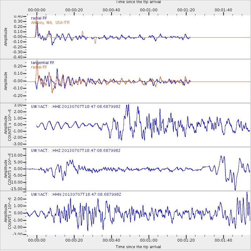
YACT Amboy, WA, USA - Earthquake Result Viewer

| Earthquake location: |
New Ireland Region, P.N.G. |
| Earthquake latitude/longitude: |
-3.9/153.9 |
| Earthquake time(UTC): |
2013/07/07 (188) 18:35:30 GMT |
| Earthquake Depth: |
386 km |
| Earthquake Magnitude: |
7.3 MW, 6.5 MB, 7.3 MW |
| Earthquake Catalog/Contributor: |
NEIC PDE/NEIC PDE-W |
|
| Network: |
UW Pacific Northwest Regional Seismic Network |
| Station: |
YACT Amboy, WA, USA |
| Lat/Lon: |
45.93 N/122.42 W |
| Elevation: |
211 m |
|
| Distance: |
88.4 deg |
| Az: |
43.941 deg |
| Baz: |
262.739 deg |
| Ray Param: |
0.041725963 |
| Estimated Moho Depth: |
17.75 km |
| Estimated Crust Vp/Vs: |
1.60 |
| Assumed Crust Vp: |
6.566 km/s |
| Estimated Crust Vs: |
4.104 km/s |
| Estimated Crust Poisson's Ratio: |
0.18 |
|
| Radial Match: |
83.71231 % |
| Radial Bump: |
400 |
| Transverse Match: |
69.245926 % |
| Transverse Bump: |
400 |
| SOD ConfigId: |
512894 |
| Insert Time: |
2013-09-15 15:10:57.559 +0000 |
| GWidth: |
2.5 |
| Max Bumps: |
400 |
| Tol: |
0.001 |
|
Signal To Noise
| Channel | StoN | STA | LTA |
| UW:YACT: :HHZ:20130707T18:47:08.687998Z | 2.1122298 | 8.57746E-7 | 4.0608555E-7 |
| UW:YACT: :HHN:20130707T18:47:08.687998Z | 1.7798125 | 3.0370242E-7 | 1.7063732E-7 |
| UW:YACT: :HHE:20130707T18:47:08.687998Z | 0.9256306 | 3.202136E-7 | 3.45941E-7 |
| Arrivals |
| Ps | 1.7 SECOND |
| PpPs | 6.9 SECOND |
| PsPs/PpSs | 8.5 SECOND |


