You are here: Home > Network List > TA - USArray Transportable Network (new EarthScope stations) Stations List
> Station M47A Cromwell, IN, USA > Earthquake Result Viewer
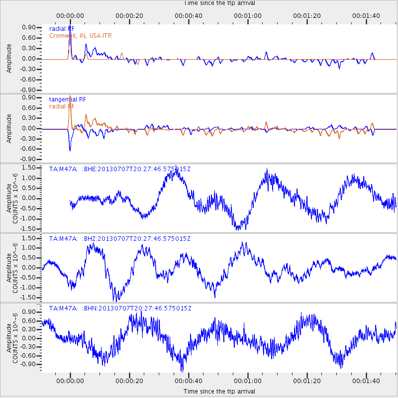
M47A Cromwell, IN, USA - Earthquake Result Viewer
*The percent match for this event was below the threshold and hence no stack was calculated.
| Earthquake location: |
Andreanof Islands, Aleutian Is. |
| Earthquake latitude/longitude: |
51.0/-179.9 |
| Earthquake time(UTC): |
2013/07/07 (188) 20:17:59 GMT |
| Earthquake Depth: |
6.8 km |
| Earthquake Magnitude: |
5.6 MB, 5.5 ML |
| Earthquake Catalog/Contributor: |
NEIC PDE/NEIC PDE-W |
|
| Network: |
TA USArray Transportable Network (new EarthScope stations) |
| Station: |
M47A Cromwell, IN, USA |
| Lat/Lon: |
41.36 N/85.62 W |
| Elevation: |
283 m |
|
| Distance: |
61.6 deg |
| Az: |
58.539 deg |
| Baz: |
314.313 deg |
| Ray Param: |
$rayparam |
*The percent match for this event was below the threshold and hence was not used in the summary stack. |
|
| Radial Match: |
60.47848 % |
| Radial Bump: |
396 |
| Transverse Match: |
65.53457 % |
| Transverse Bump: |
400 |
| SOD ConfigId: |
512894 |
| Insert Time: |
2013-09-15 15:42:09.010 +0000 |
| GWidth: |
2.5 |
| Max Bumps: |
400 |
| Tol: |
0.001 |
|
Signal To Noise
| Channel | StoN | STA | LTA |
| TA:M47A: :BHZ:20130707T20:27:46.575015Z | 1.8843505 | 6.280556E-7 | 3.3330082E-7 |
| TA:M47A: :BHN:20130707T20:27:46.575015Z | 0.4168969 | 1.3669776E-7 | 3.2789345E-7 |
| TA:M47A: :BHE:20130707T20:27:46.575015Z | 3.5054698 | 9.459341E-7 | 2.6984517E-7 |
| Arrivals |
| Ps | |
| PpPs | |
| PsPs/PpSs | |


