You are here: Home > Network List > TA - USArray Transportable Network (new EarthScope stations) Stations List
> Station O45A Potomac, IL, USA > Earthquake Result Viewer
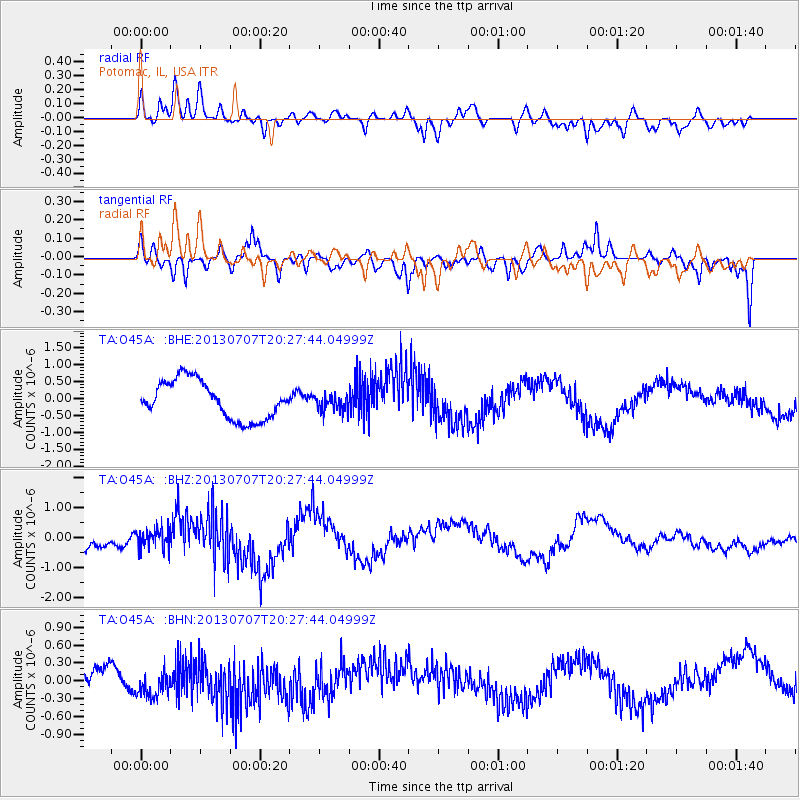
O45A Potomac, IL, USA - Earthquake Result Viewer
*The percent match for this event was below the threshold and hence no stack was calculated.
| Earthquake location: |
Andreanof Islands, Aleutian Is. |
| Earthquake latitude/longitude: |
51.0/-179.9 |
| Earthquake time(UTC): |
2013/07/07 (188) 20:17:59 GMT |
| Earthquake Depth: |
6.8 km |
| Earthquake Magnitude: |
5.6 MB, 5.5 ML |
| Earthquake Catalog/Contributor: |
NEIC PDE/NEIC PDE-W |
|
| Network: |
TA USArray Transportable Network (new EarthScope stations) |
| Station: |
O45A Potomac, IL, USA |
| Lat/Lon: |
40.25 N/87.72 W |
| Elevation: |
208 m |
|
| Distance: |
61.3 deg |
| Az: |
60.711 deg |
| Baz: |
313.982 deg |
| Ray Param: |
$rayparam |
*The percent match for this event was below the threshold and hence was not used in the summary stack. |
|
| Radial Match: |
68.77985 % |
| Radial Bump: |
400 |
| Transverse Match: |
63.22677 % |
| Transverse Bump: |
395 |
| SOD ConfigId: |
512894 |
| Insert Time: |
2013-09-15 15:43:34.087 +0000 |
| GWidth: |
2.5 |
| Max Bumps: |
400 |
| Tol: |
0.001 |
|
Signal To Noise
| Channel | StoN | STA | LTA |
| TA:O45A: :BHZ:20130707T20:27:44.04999Z | 1.129396 | 3.13465E-7 | 2.7755104E-7 |
| TA:O45A: :BHN:20130707T20:27:44.04999Z | 0.7496243 | 2.8204414E-7 | 3.762473E-7 |
| TA:O45A: :BHE:20130707T20:27:44.04999Z | 0.43970013 | 2.4302915E-7 | 5.527157E-7 |
| Arrivals |
| Ps | |
| PpPs | |
| PsPs/PpSs | |


