You are here: Home > Network List > TA - USArray Transportable Network (new EarthScope stations) Stations List
> Station P54A Burton, WV, USA > Earthquake Result Viewer
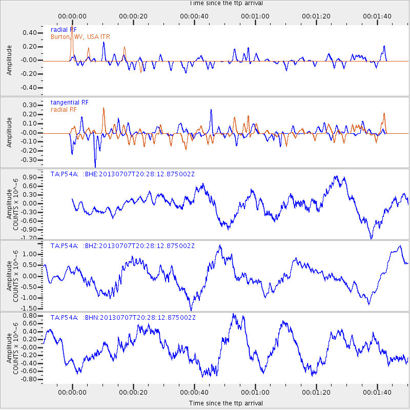
P54A Burton, WV, USA - Earthquake Result Viewer
*The percent match for this event was below the threshold and hence no stack was calculated.
| Earthquake location: |
Andreanof Islands, Aleutian Is. |
| Earthquake latitude/longitude: |
51.0/-179.9 |
| Earthquake time(UTC): |
2013/07/07 (188) 20:17:59 GMT |
| Earthquake Depth: |
6.8 km |
| Earthquake Magnitude: |
5.6 MB, 5.5 ML |
| Earthquake Catalog/Contributor: |
NEIC PDE/NEIC PDE-W |
|
| Network: |
TA USArray Transportable Network (new EarthScope stations) |
| Station: |
P54A Burton, WV, USA |
| Lat/Lon: |
39.61 N/80.48 W |
| Elevation: |
473 m |
|
| Distance: |
65.6 deg |
| Az: |
56.778 deg |
| Baz: |
316.857 deg |
| Ray Param: |
$rayparam |
*The percent match for this event was below the threshold and hence was not used in the summary stack. |
|
| Radial Match: |
56.1022 % |
| Radial Bump: |
400 |
| Transverse Match: |
74.75142 % |
| Transverse Bump: |
400 |
| SOD ConfigId: |
512894 |
| Insert Time: |
2013-09-15 15:44:36.707 +0000 |
| GWidth: |
2.5 |
| Max Bumps: |
400 |
| Tol: |
0.001 |
|
Signal To Noise
| Channel | StoN | STA | LTA |
| TA:P54A: :BHZ:20130707T20:28:12.875002Z | 0.58069897 | 2.6942453E-7 | 4.6396596E-7 |
| TA:P54A: :BHN:20130707T20:28:12.875002Z | 2.4362478 | 4.96518E-7 | 2.0380439E-7 |
| TA:P54A: :BHE:20130707T20:28:12.875002Z | 1.2307999 | 2.3453215E-7 | 1.9055263E-7 |
| Arrivals |
| Ps | |
| PpPs | |
| PsPs/PpSs | |


