You are here: Home > Network List > TA - USArray Transportable Network (new EarthScope stations) Stations List
> Station R53A Hurricane, WV, USA > Earthquake Result Viewer
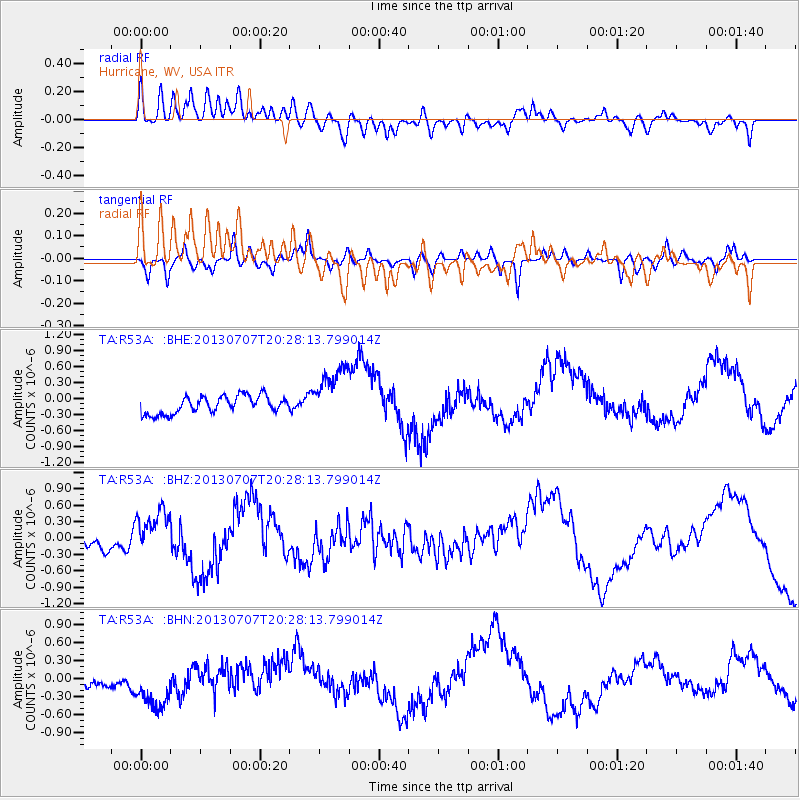
R53A Hurricane, WV, USA - Earthquake Result Viewer
*The percent match for this event was below the threshold and hence no stack was calculated.
| Earthquake location: |
Andreanof Islands, Aleutian Is. |
| Earthquake latitude/longitude: |
51.0/-179.9 |
| Earthquake time(UTC): |
2013/07/07 (188) 20:17:59 GMT |
| Earthquake Depth: |
6.8 km |
| Earthquake Magnitude: |
5.6 MB, 5.5 ML |
| Earthquake Catalog/Contributor: |
NEIC PDE/NEIC PDE-W |
|
| Network: |
TA USArray Transportable Network (new EarthScope stations) |
| Station: |
R53A Hurricane, WV, USA |
| Lat/Lon: |
38.33 N/81.95 W |
| Elevation: |
294 m |
|
| Distance: |
65.8 deg |
| Az: |
58.654 deg |
| Baz: |
316.707 deg |
| Ray Param: |
$rayparam |
*The percent match for this event was below the threshold and hence was not used in the summary stack. |
|
| Radial Match: |
38.86258 % |
| Radial Bump: |
400 |
| Transverse Match: |
26.087107 % |
| Transverse Bump: |
342 |
| SOD ConfigId: |
512894 |
| Insert Time: |
2013-09-15 15:45:51.310 +0000 |
| GWidth: |
2.5 |
| Max Bumps: |
400 |
| Tol: |
0.001 |
|
Signal To Noise
| Channel | StoN | STA | LTA |
| TA:R53A: :BHZ:20130707T20:28:13.799014Z | 0.99557495 | 3.4933421E-7 | 3.5088692E-7 |
| TA:R53A: :BHN:20130707T20:28:13.799014Z | 2.3334012 | 4.174364E-7 | 1.7889612E-7 |
| TA:R53A: :BHE:20130707T20:28:13.799014Z | 3.2240467 | 5.241603E-7 | 1.6257839E-7 |
| Arrivals |
| Ps | |
| PpPs | |
| PsPs/PpSs | |


